San Francisco drivers don’t want much: reasonably maintained roads, working traffic signals and clear signage. But what city drivers get, some say, is a “nightmare.”
City roads are shared among drivers, bicyclists, pedestrians, e-scooters, e-bikes, Muni buses, trains, cable cars and an increasing number of robotaxis. Throw in the occasional intersection where freeway traffic meets public transit and a bike lane, and you’ve got a recipe for frustration or even danger.
The Standard asked San Francisco drivers to tell us their most hated intersections and then looked into crash data and asked the city’s transit agency what the plan was to fix them—if there was one.
Below is a collection of your most hated intersections, an analysis of incident data and responses from the San Francisco Municipal Transportation Agency on what they’re doing about it:
Potrero Avenue and 16th Street, and Potrero and Jerrold avenues, Marin and Cesar Chavez streets and Bayshore Boulevard
Along Potrero Avenue, where the borders of the Mission District and Potrero Hill meet, drivers told The Standard that having to merge vehicles means “tempers get flared, obscenities are yelled, and one-fingered hand gestures abound.”
Traffic along this artery drew complaints at two key intersections. One is 16th Street and Potrero Avenue; one reader said driving through this intersection “makes my palms sweat” due to westbound 16th Street drivers turning right into a busy retail shopping center. Eastbound drivers on 16th complained about the narrowing of two lanes to one after crossing Potrero Avenue.
At the other intersection, where the southern end of Potrero Avenue meets Jerrold Avenue, Marin and Cesar Chavez streets and Bayshore Boulevard, a reader complained of regularly encountering “giant trucks trying to get to the produce market” with poor sidewalk surface and “clearly marked, but routinely ignored” lanes.

What the data says:
According to San Francisco Police Department’s interim collision data system, 40 vehicle collisions resulted in injury from 2018 to 2023 at 16th and Potrero. There were also two fatal crashes at Potrero and 16th, and one at Bayshore and Cesar Chavez during the same period.
What the SFMTA says:
Spokesperson Stephen Chun told The Standard that existing transit lanes on 16th and Potrero should assist with traffic flow. Chun also referred to the agency’s Cesar Chavez/Potrero Avenue/Bayshore Boulevard intersection project page, which calls the intersection “the Hairball,” and said the city’s Department of Public Works was taking the lead on the sidewalk surface issue. Public Works has already made bicycle and pedestrian path improvements from 2019 to 2021.
Central Freeway Intersections

At the Mission District’s northern edge, the Central Freeway section of Highway 101 funnels thousands of drivers down an off-ramp into an intersection where Duboce Avenue meets the end of Otis Street and crosses Mission Street.
The intersection is one of several that readers complained about for confusing layouts. Others are Duboce Avenue and Guerrero Street, and Division Street from Eighth to 11th streets.
Another multi-street intersection further east under the Central Freeway at San Bruno Avenue at Division and Ninth streets worried a reader who said the lack of a stoplight made left turns difficult there.

What the data says:
According to SFPD’s interim collision data system, there were 39 vehicle collisions at Duboce and Otis/Mission/Highway 101 that resulted in injury from 2018 to 2023. Data for the intersection of San Bruno Avenue and Division and Ninth streets was not available.
What the SFMTA said:
Chun told The Standard that many of those intersections were subject to “congestion or configuration issues that date back to the original layout of city streets, most of which predated the automobile era.” Chun added that the intersection of San Bruno Avenue at Division and Ninth streets will get a traffic signal shortly.
On a lighter note, if you’d get like to get involved with The Standard’s coverage: Why not tell us your thoughts on the most beautiful block, street or spot with a view in San Francisco? Email tips@sfstandard.com with “Most Beautiful” in the subject line and a description of your most beloved city vista.
Van Ness Avenue and Market Street

This intersection at the southern edge of the city’s Civic Center is home to the All-Star Diner and a Bank of America branch, as well as an underground Muni light rail station. It’s also a few steps from the SFMTA’s customer service center on South Van Ness Avenue, south of Market Street.
Its centrality and width may have been what led one reader to call it one of several unnamed intersections that “should be traffic circles with fountains,” similar to New York City’s Columbus Circle.
What the data says:
Market Street and Van Ness Avenue had 26 vehicle collisions that resulted in injury from 2018 to 2023, according to SFPD’s interim collision data system.
What the SFMTA said:
As it turns out, Chun noted that prominent city planner Daniel Burnham had proposed a traffic circle there in a plan a year before the 1906 earthquake.
Chun said a traffic circle would be inefficient as it would have to manage the flow of bikes, pedestrians, vehicles and buses, as well as the flow of highway traffic.
Turk and Hyde streets

At the southern end of the Tenderloin, southbound one-way traffic surges along Hyde Street across westbound traffic on Turk Street. But the issue here has more to do with people running across the intersection and a possible need for improved signals and crossings, according to a local-born reader.
What the data says:
According to SFPD’s interim collision data system, Turk and Hyde streets saw 26 vehicle collisions that resulted in injury from 2018 to 2023.
What the SFMTA said:
Call 311 to address traffic concerns.
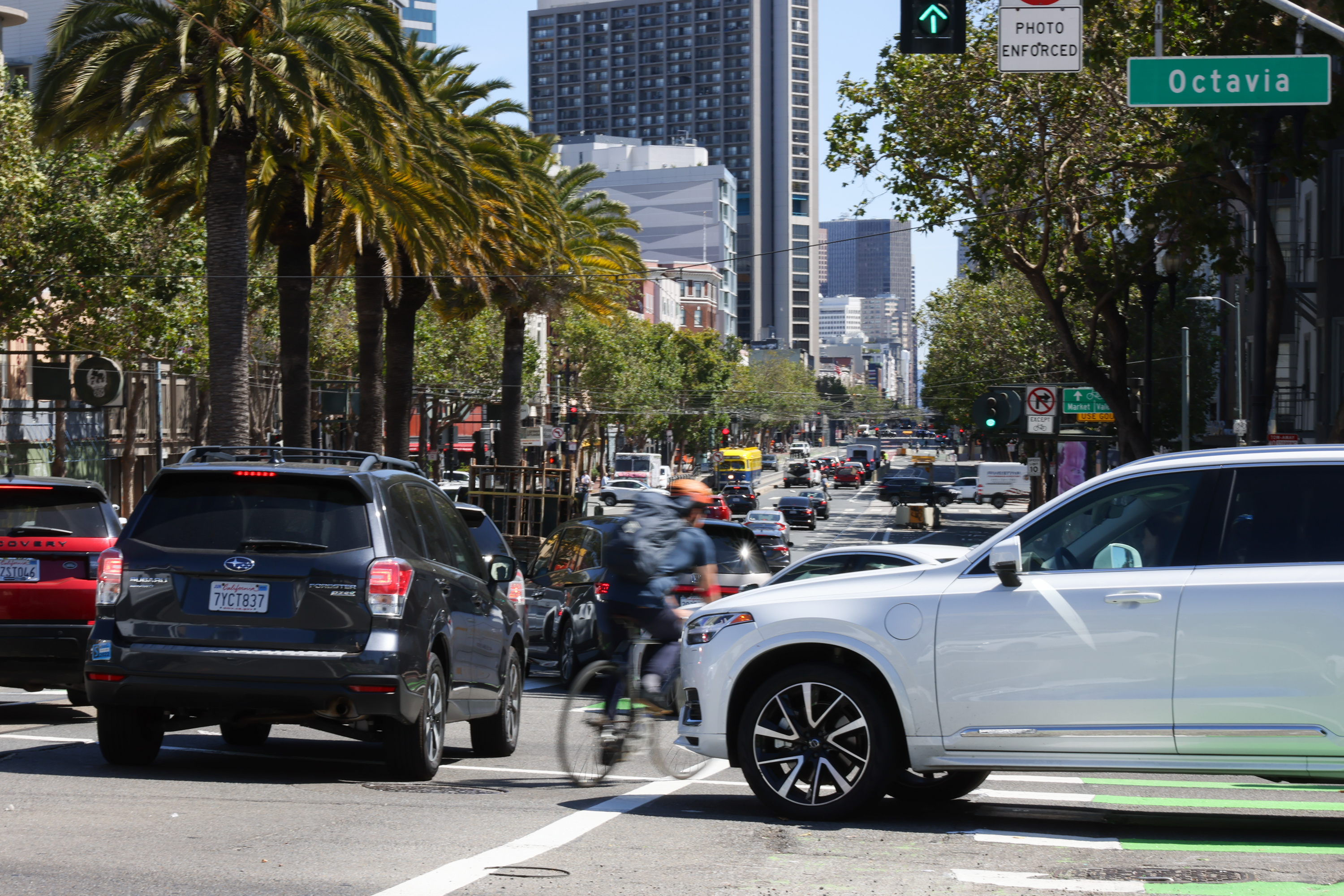
Octavia and Oak streets

Northbound Octavia Street traffic parallels Octavia Boulevard before meeting eastbound traffic on the southern end of Hayes Valley.
A reader raised alarms about eastbound Oak Street lanes turning onto the boulevard, while another described the crossing’s “terrible long light cycle for pedestrians to scurry across while cars are waiting to pounce.”
What the data says:
According to SFPD’s interim collision data system, Octavia and Oak streets had 24 vehicle collisions that resulted in injury from 2018 to 2023.
What the SFMTA said:
Chun referred The Standard to the agency’s Octavia Boulevard Enhancement Program page and said staff would look into retiming the traffic signals for the intersections of Octavia at Oak and Fell streets.

Market and Laguna streets
Northbound and southbound traffic flows along Laguna Street, which meets Market Street at a brick-lined intersection watched over by the Orbit Room cocktail bar.
Here, a green light for southbound Laguna drivers “doesn’t give enough time,” only allowing a few cars at a time to cross over to the foot of Guerrero Street, said one reader.
What the data says:
According to SFPD’s interim collision data system, Market and Laguna streets saw 24 vehicle collisions that resulted in injury from 2018 to 2023.
What the SFMTA said:
Call 311 to address traffic concerns.
17th and Market streets

Here, a reader said drivers often speed downhill along Market Street and pass the Pink Triangle Memorial before approaching Castro Street underneath the iconic Gilbert Baker memorial rainbow flag, while other Market Street vehicles must veer west after crossing Castro Street onto a single-lane 17th Street.
What the data says:
According to SFPD’s interim collision data system, 17th and Market streets had 24 vehicle collisions that resulted in injury from 2018 to 2023.
What the SFMTA said:
Call 311 to address traffic concerns.
Chun also said many intersections along Upper Market Street have had recent upgrades through two projects, pointing to the agency’s Upper Market Street Safety Project page as well as the Department of Public Works’ corridor safety improvements project page.
Bryant and Fifth streets

Here, four lanes of eastbound Bryant Street traffic surge across northbound and southbound Fifth Street drivers’ paths, causing one reader to bemoan the absence of lane markers heading onto a Highway 101 on-ramp.
What the data says:
According to SFPD’s interim collision data system, Bryant and Fifth streets saw 21 vehicle collisions that resulted in injury from 2018 to 2023.
What the SFMTA said:
Call 311 to address traffic concerns.
Market and Fourth streets, Stockton and O’Farrell streets
This intersection, formerly home to an Old Navy store that closed in July, still hosts a chain candy store and a clothing retailer. Muni buses, BART’s Powell Street Station and a street-car line meet at the intersection.
A Standard reader who works as an architect described the streets’ intersection with Stockton and O’Farrell streets as chaotic. If he had his way, he said, he’d bring in landscaping, artwork and a scramble crosswalk that allowed pedestrians to cross all at once.
What the data says:
According to SFPD’s interim collision data system, Market and Fourth streets had 20 vehicle collisions that resulted in injury from 2018 to 2023, with Stockton and O’Farrell streets logging nine separate similar crashes.
What the SFMTA said:
Chun referred The Standard to the Public Works’ Better Market Project campaign, which has worked to renew and improve Market from Octavia to Steuart streets after drawing on a decade’s worth of planning, workshops and meetings.
Market, Noe and 16th streets
“Fix it Jesus!” wrote of one several readers who complained about this meeting of three streets, complete with a Muni line for added confusion. Another called the intersection a “general shit show.” The complaints about this intersection centered on the lights being too fast and cars becoming stuck in the intersection.
Whoever designed the intersections should be “mercilessly shamed,” according to one agitated reader.
What the data says:
According to SFPD’s interim collision data system, Market, Noe and 16th streets saw 19 vehicle collisions that resulted in injury from 2018 to 2023.
What the SFMTA said:
Chun asked readers to check out the Upper Market Street Safety Project for updates on this intersection.
Sanchez and Market streets

Here, northbound and southbound Sanchez drivers meet eastbound and westbound 15th Street drivers by crossing Market Street traffic in both directions.
A Standard reader said that drivers traveling south along Sanchez have no lane indicators showing where to turn left or right onto Market, resulting in delays.
What the data says:
According to SFPD’s interim collision data system, Market and Fourth streets had 15 vehicle collisions that resulted in injury from 2018 to 2023.
What the SFMTA said:
Call 311 to address traffic concerns.
Chun said many intersections along Upper Market Street have had recent upgrades through two projects, pointing to the agency’s Upper Market Street Safety Project page as well as the city Department of Public Works’ corridor safety improvements project page.
Fulton and Stanyan streets
A Standard reader called this intersection at the northeast corner of Golden Gate Park a “strong candidate for worst SF intersections list,” but did not elaborate further.
What the data says:
According to SFPD’s interim collision data system, Fulton and Stanyan streets saw 14 vehicle collisions that resulted in injury from 2018 to 2023.
What the SFMTA said:
Chun did not directly address this intersection.
Evans Avenue and Mendell Street
A reader pointed out a particular issue with a signal along eastbound Evans Avenue approaching Mendell Street.
According to the reader, who described himself as a motorcyclist and former messenger, drivers on Evans appeared to miss the Mendell signal and fixate on a traffic signal hanging over Evans about 1/10th of a mile past the intersection.
“Many times I’ve looked down the road and seen the green light at the post office and not noticed the red light at Mendell until the last second,” he said. “A couple of times I’ve come upon a crash scene at that intersection where the eastbound Evans car has T-boned a car crossing on Mendell.”
What the data says:
According to SFPD’s interim collision data system, Evans and Mendell had 14 vehicle collisions that resulted in injury from 2018 to 2023.
What the SFMTA said:
Chun told The Standard the transit agency was taking a closer look at the intersection. Chun then urged any residents who noticed trees blocking traffic signals to call 311 to alert Public Works staff to schedule tree-trimming.
19th and 20th avenues and Lincoln Way
Here, southbound Crossover Drive and northbound 19th Avenue traffic meet eastbound and westbound Lincoln Way drivers at the southern edge of Golden Gate Park.
A reader called the 19th Avenue intersection “a total cluster whether you’re going north/south or east/west,” describing it as “unsafe all around with so much driving bad behavior with scary conditions for pedestrians and those waiting for the bus. Plus, it’s ugly.”
Another reader said northbound 19th Avenue drivers see daily congestion backed up two or three blocks, increasing to five or six blocks on weekends, with westbound Lincoln drivers making right-hand turns onto Crossover also seeing weekend tailbacks.
The 20th Avenue intersection didn’t score much higher, with a reader calling Lincoln from 20th Avenue over to Frederick and Stanyan streets “a street with particularly poor design for transit and pedestrians especially given how much foot traffic Golden Gate Park gets.” Hey, at least it has Chug Pub!
What the data says:
According to SFPD’s interim collision data system, Lincoln Way intersections saw 21 vehicle collisions that resulted in injury from 2018 to 2023, with 11 collisions at 19th Avenue and 10 at 20th Avenue.
What the SFMTA said:
Chun told The Standard that traffic buildup at 19th and Lincoln Way is “due in part to Golden Gate Park breaking up the city’s traditional grid and concentrating traffic on Highway 1. There is an enormous amount of people driving on a street system that concentrates all the traffic onto this location.”
Geary Boulevard and Franklin Street
A block east of Van Ness Avenue in the city’s Cathedral Hill neighborhood, northbound traffic courses up Franklin Street before crossing the paths of eastbound Geary Boulevard drivers.
Here, a Standard reader noted the multiple uphill lanes, calling out “so many rideshare cars trying to turn right on red from Geary to Franklin.”
The reader also worried about “fast and sight obscured” traffic along Franklin, with drivers turning at speed, putting crosswalk pedestrians at risk, as well as what he called “a weird amount of sidewalk scooters.”
What the data says:
According to SFPD’s interim collision data system, Geary and Franklin had nine vehicle collisions that resulted in injury from 2018 to 2023.
What the SFMTA said:
Chun told The Standard that SFMTA operations staff had previously looked at this intersection but are working to reassess their earlier decision.
Eucalyptus Drive and Ocean Avenue
Here, eastbound and westbound Eucalyptus Drive traffic meets the multilane intersection of the restaurant-rich Ocean Avenue with Junipero Serra Boulevard.
A reader expressed concern about having to make multiple lane changes across Ocean traffic when eastbound on Eucalyptus and trying to turn north onto Serra.
What the data says:
According to SFPD’s interim collision data system, Eucalyptus Drive and Ocean Avenue saw nine vehicle collisions that resulted in injury from 2018 to 2023.
What the SFMTA said:
Call 311 to address traffic concerns.
Sloat, Junipero Serra and St. Francis boulevards with West Portal Avenue and Portola Drive

Standard readers complained heartily about Sloat Boulevard, with one pointing to its intersection with Portola Drive, West Portal Avenue and Junipero Serra and St. Francis boulevards.
“It’s a clash of five different roads starting/ending, with Muni tracks running through it,” one reader said. “God forbid you’re approaching from the St. Francis side; you could wait 10 minutes for the light to change if a train comes when it’s your turn for the green light. The Portola entry can also get very bad on weekends.”
Another reader said the intersection didn’t qualify as the city’s most dangerous. But he qualified that by saying it was one “where more people spend time sitting with one foot firmly planted on the brake pedal waiting, and waiting, and waiting.
“The joke is that if you are standing on Sloat Boulevard at St. Francis Circle, and you are waiting for the 23-Monterey Bus, you should bring a book to read while you wait,” he added. “But if you are sitting in your car waiting for your green light, you might see a 23-Monterey bus first.”
What the data says:
According to SFPD’s interim collision data system, the five-way intersection had 8 vehicle collisions that resulted in injury from 2018 to 2023.
Sloat Boulevard and 19th Avenue saw 26 crashes over the same period, while Junipero Serra Boulevard and 19th Avenue saw 25 crashes.
What the SFMTA said:
Chun told The Standard that traffic signal timing on St. Francis Circle favors cross-street car trains that can slow traffic at times. “The location itself is not unsafe, just subject to delay,” he said.
Oak and Cole streets
A Standard reader shared a concern from his morning commute after noticing other drivers speeding to beat yellow or run red lights to cross Cole Street in the Panhandle.
“There are occasionally early riser joggers and I’m super worried one will be killed eventually by these light runners,” he said. “Anyhow, seeing such dangerous driving makes my blood boil. If the one light was timed with the rest, it wouldn’t create this problem.”
What the data says:
According to SFPD’s interim collision data system, Oak and Cole streets saw six vehicle collisions that resulted in injury from 2018 to 2023.
What the SFMTA said:
Chun said staff would look into retiming the signal at Oak and Cole streets.
Union and Laguna streets
Near the center of the Union Street shopping district, northbound and southbound Laguna Street traffic meets eastbound and westbound Union Street drivers.
A Standard reader expressed concern about pedestrians along Union Street who “don’t look both ways while crossing, they just keep walking at the same pace.”
What the data says:
According to SFPD’s interim collision data system, Union and Laguna streets had five vehicle collisions that resulted in injury from 2018 to 2023.
What the SFMTA said:
Call 311 to address traffic concerns.
Marina Boulevard and Fillmore Street
The long, wide-open stretch of Marina Boulevard meets the end of Fillmore Street at the city’s northern edge beside Marina Green. The vistas here are breathtaking, but also distracting for some.
Accordingly, a reader complained about traffic from cross streets like Avila Street, Casa Way and Retiro Way entering Marina between Fillmore Street and Scott Street near the west end of Marina Green.
What the data says:
According to SFPD’s interim collision data system, Marina Boulevard and Fillmore Street saw four vehicle collisions that resulted in injury from 2018 to 2023.
What the SFMTA said:
Call 311 to address traffic concerns.
Laguna and Hayes streets
In the center of Hayes Valley, eastbound and westbound Hayes Street traffic meets northbound and southbound Laguna Street traffic.
With plenty of restaurants and shops close by, a Standard reader expressed concern that pedestrians don’t look both ways before walking and don’t allow cars to cross, often with northbound Laguna traffic.
What the data says:
According to SFPD’s interim collision data system, Laguna and Hayes streets had four vehicle collisions that resulted in injury from 2018 to 2023.
What the SFMTA said:
Call 311 to address traffic concerns.
California and Baker streets
Here, eastbound and westbound California Street traffic meets northbound and southbound Baker Street vehicles and northbound Laguna traffic. A Standard reader says a stoplight “needs to be in the middle” because “people go through red at 40 all the time.”
What the data says:
According to SFPD’s interim collision data system, California and Baker streets saw two vehicle collisions that resulted in injury from 2018 to 2023.
What the SFMTA said:
Chun said staff are still discussing plans for the intersection.
24th Avenue and Clement Street
Here, northbound and southbound 24th Avenue traffic meets westbound and eastbound vehicles taking in restaurants, coffee shops and other establishments along the Clement Street retail corridor.
A reader called the intersection “a free for all,” saying it could be beneficial to install four-way stop signs, not just two-way ones.
What the data says:
According to SFPD’s interim collision data system, 24th Avenue and Clement Street had one vehicle collision that resulted in injury from 2018 to 2023.
What the SFMTA said:
Chun said SFMTA staff will look into the intersection’s needs.