Editor’s note: This article has been updated to include an announcement by city officials on Feb. 3 regarding traffic calming measures for the Lower Great Highway and Outer Sunset.
A trio of senior women power walks down the Great Highway, swiftly moving their arms back and forth. Engaged in conversation, they laugh as the sun reflects on their visors.
Several feet ahead, a “critical mass” of bicyclists rolls down the walkway in the opposite direction in multicolored wigs, with strings of lights flashing on their bikes—the cyclist leading the ride blasts “Lovely Day” by Bill Withers from a speaker in the basket of his bike.
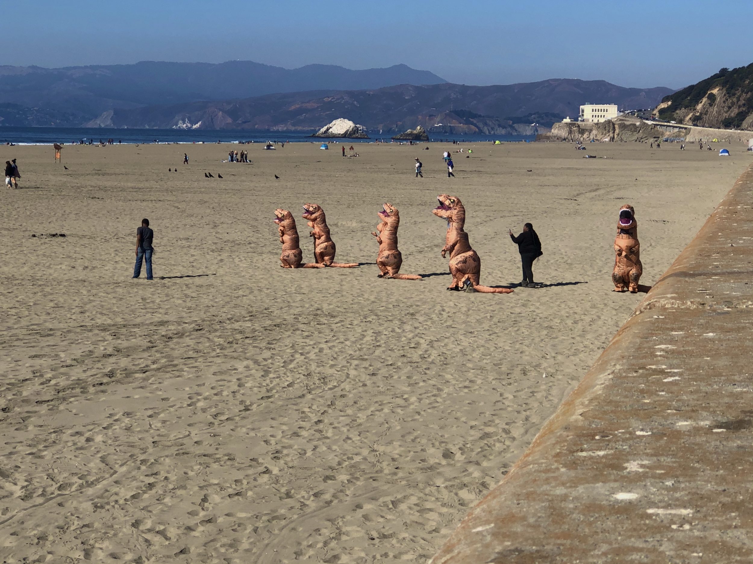
And following them—a family of five in dinosaur costumes shuffles down the steps from the Great Highway onto the beach. Trying to keep up, the youngest face plants into the sand, and his siblings run to his aide.
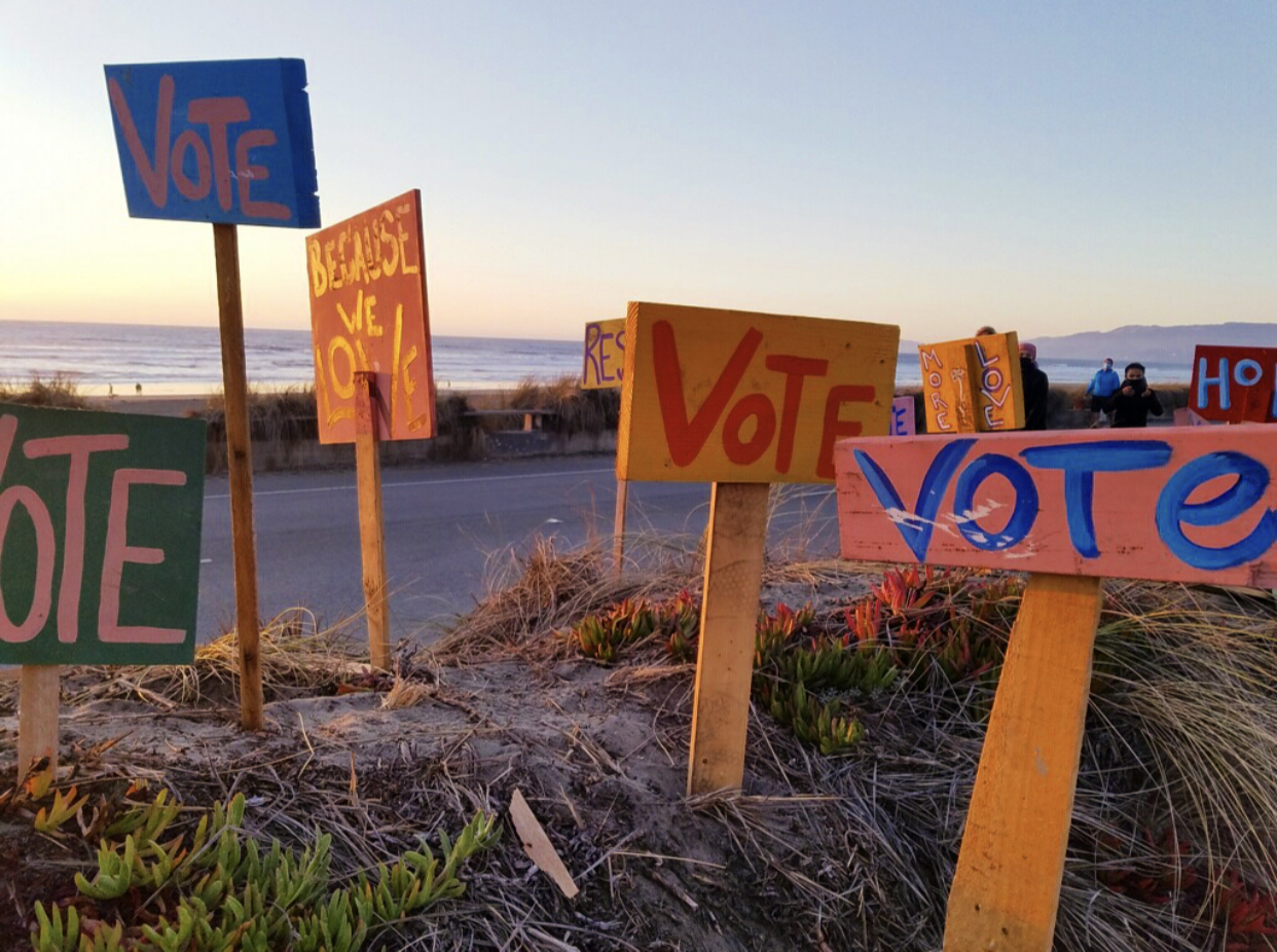
For a moment, it looks like the old San Francisco. A sense of normalcy and community lingers in the ocean air.
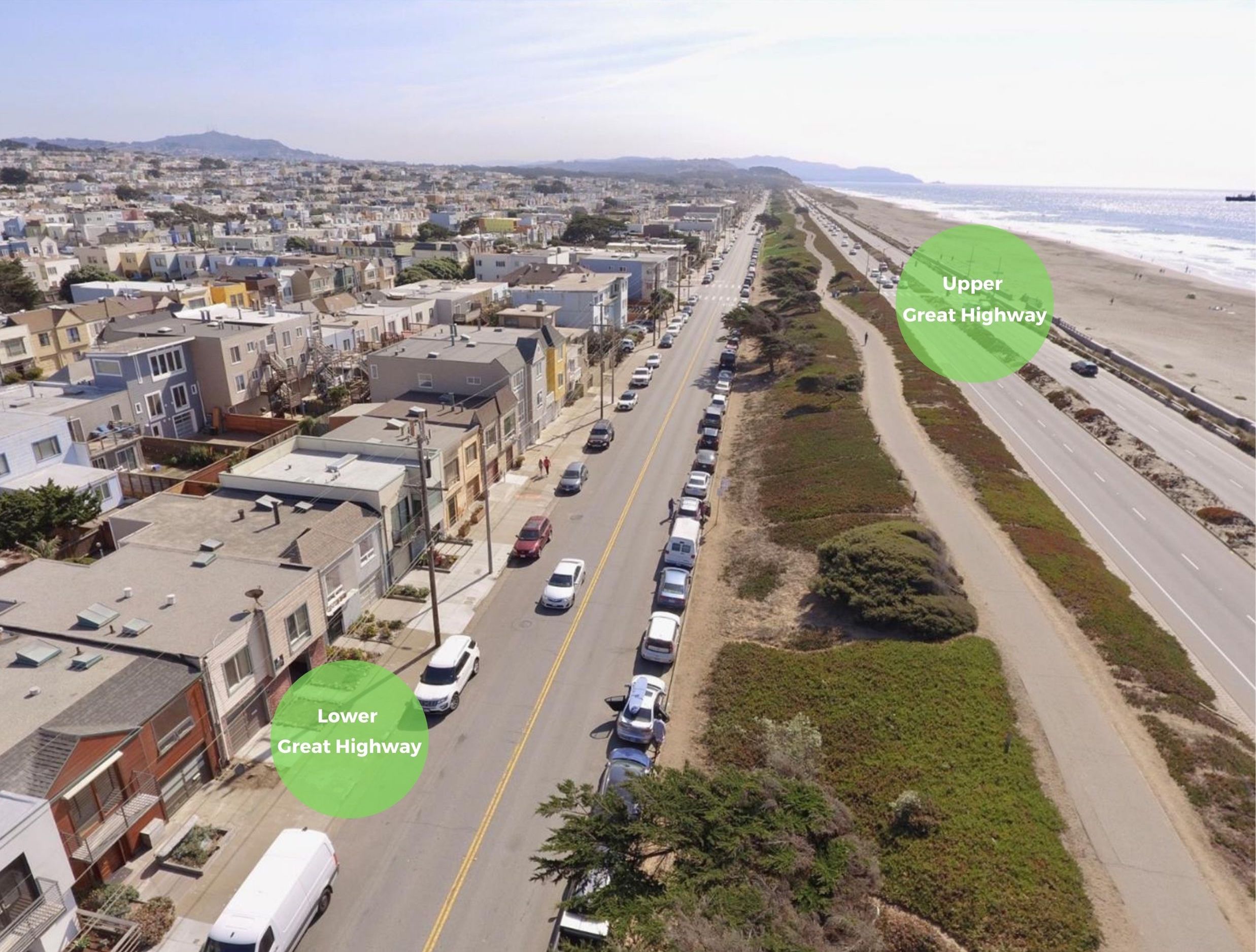
However, it is not all about “having fun in the fog” for everyone. While the city’s decision to close the Upper Great Highway to vehicles has transformed the roadway into a temporary promenade for stir-crazy San Franciscans, it has also created a traffic problem for those living on neighboring streets. A debate over the Great Highway’s partial closure—and whether it should reopen to cars—is underway.
But even more pressing is the fact that, in the next few years, the roadway will be transformed. Not by any policy or political choice, but by climate change and coastal erosion.
Great Highway’s Temporary Closure Sparks Broad Debate Over Roadway’s Future
Last April, when Supervisor Gordon Mar announced the Upper Great Highway’s temporary closure to cars (which spans from Lincoln Way to Sloat Boulevard) he intended to mitigate the impact of sand on the roadway to oncoming vehicles. The Upper Great Highway closure is nothing new. In pre-Covid times, it closed on average at least 27 times every year for cleanups.
However, Mar opted to keep the roadway shut this time around as part of San Francisco’s Slow Streets initiative to create more space for District 4 residents to socially distance. Since then, the Upper Great Highway has remained off limits to cars and open to thousands of people of different ages, races, genders and abilities.
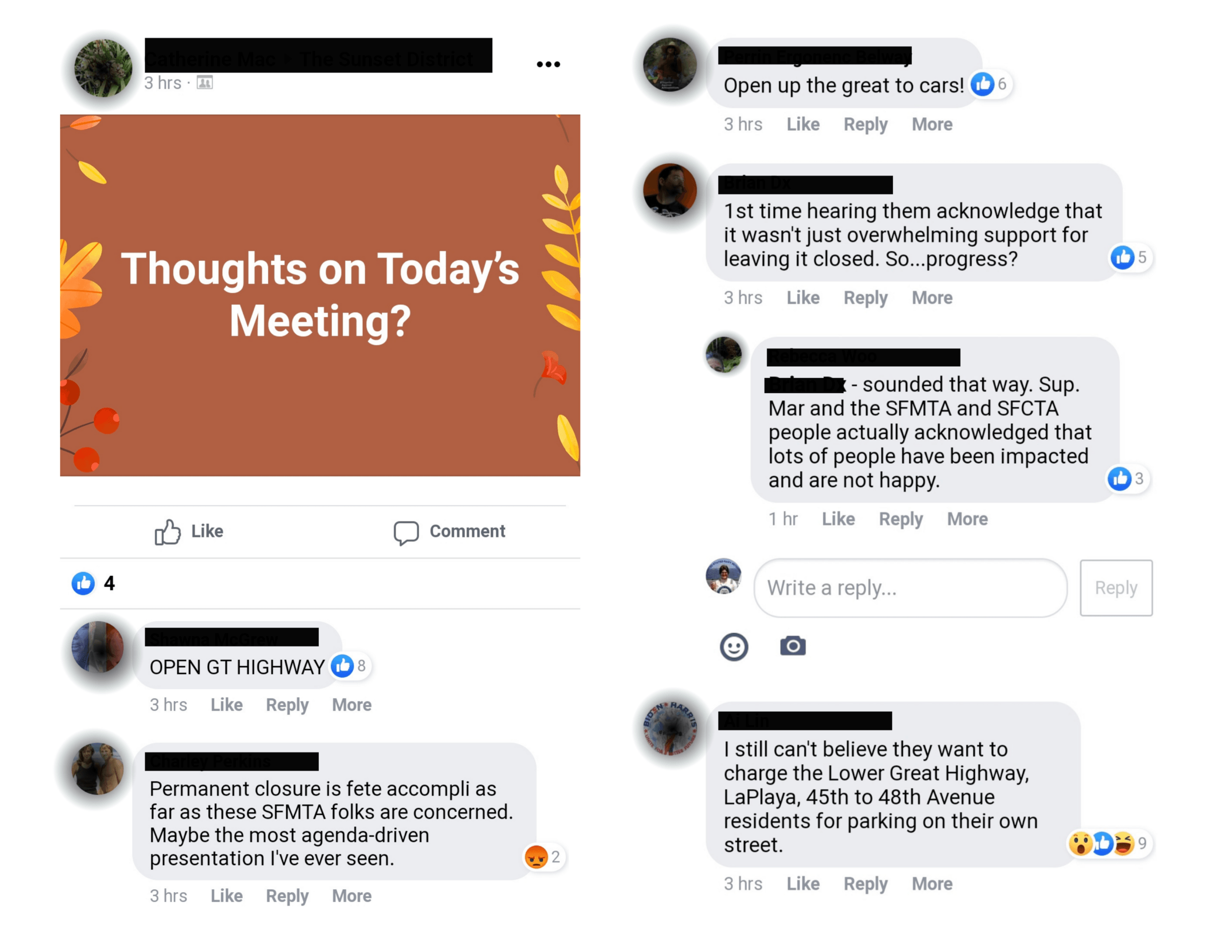
“It has been a backdrop for marches of racial justice,” said Mar during a town hall meeting last November that drew more than 500 participants, a mixture of community groups advocating to keep the closure and frustrated residents asking for the highway to reopen. “It is also a training ground for kids learning to ride bikes and a new iconic space for San Franciscans to maintain their physical and mental health in these trying times.”
While this new use of the Upper Great Highway has been tremendously successful in meeting that goal, it has also presented real and severe challenges resulting from the traffic diverted onto the Outer Sunset’s residential streets, specifically the Lower Great Highway. Through a series of virtual meetings with Supervisor Mar, residents, and members of the San Francisco Municipal Transportation Agency (SFMTA), it was determined that the Lower Great Highway had experienced an increased traffic volume of over 5,000 cars a day, with a significant percentage of those cars driving at unsafe speeds.
The SFMTA has since taken steps to address these safety and traffic concerns, such as adding detour signs and new turn restrictions to redirect Sunset Boulevard’s traffic. Meanwhile, several neighborhood groups are advocating to maintain the roadway’s closure. One such group, the Great Highway Park Initiative, has collected thousands of signatures to date.
Regardless of what happens in the coming weeks, months, or however long the temporary closure continues, District 4 residents also have an opportunity to weigh in on the highway’s long-term future. This conversation will not be in response to COVID-19 but rather to climate change.
“We didn’t decide that—the planet did,” Mar said. “Nature has decided that for us.”
Climate Change Threatens San Francisco’s Coastline
Over the years, erosion along the famous strip has been exacerbated by global warming and sea level rise (abbreviated as SLR).
“Ever since the Great Highway was carved out of the sand dunes, there has been a struggle to protect the road from the powerful surf of the North Pacific,” observed a 2012 Surfrider Foundation history of coastal erosion at Ocean Beach.
A 2020 SF Planning Department assessment of sea level rise vulnerability and consequences predicts that temporary coastal flooding will impact “the entire length of the Ocean Beach/Fort Funston Shoreline trail” and that 98 percent, or 4.6 miles, of Ocean Beach will be inundated if sea level rises to 4.3 feet or above. The Great Highway itself could be inundated anywhere from 10 to 22 percent (.4 to .8 miles) depending on the degree of sea level rise, with coastal floodwaters and SLR projected to overwhelm parts of its beachside trail as well. (According to an August 2020 report by California’s Legislative Analyst’s Office, SLR in the state could rise at least a half foot by 2030 and “as much as seven feet by 2100,” with storm surges, “king tides” and El Niño-like events able to “produce notably higher water levels than SLR alone”).
“The wave hazards along the Pacific Ocean shoreline are much larger than within the sheltered Bay, with wave heights exceeding 20 feet along some stretches of shoreline. As sea levels rise, the potential for wave hazards and coastal erosion will increase, because deeper ocean waters allow for the generation of larger waves,” the SF Planning Department’s assessment warns. “Coastal erosion of the oceanfront beaches and bluffs will continue to change the Westside shoreline over the coming century.”
According to the report, the Great Highway has already lost parking areas to coastal erosion, and the extension south of Sloat Boulevard will have to be closed to cars permanently in the coming years because the city cannot maintain it as a roadway. Parts of the city’s wastewater infrastructure are also under threat from coastal erosion.

Bob Battalio, a civil engineer and vice president at ESA, an environmental services firm, has been surfing at and studying Ocean Beach for 30 years. He project-managed a collaboration with the San Francisco Planning and Urban Research Association (SPUR) to develop the Ocean Beach Master Plan, which is currently being implemented and aims to mitigate the impacts of coastal erosion, climate change and sea level rise on the westside of San Francisco.
According to Battalio, the greatest environmental threats to the Great Highway are the reduction of the shoreline and coastal flooding.
“We’re going to see the beach getting narrower,” he said. As part of the Ocean Beach Master Plan, Battalio’s team recommended widening the beach with extra sand “to compensate for the effect of sea level rise” and reducing the width of the Upper Great Highway.
“We talked a lot about narrowing the Upper Great Highway to two lanes to provide more space for these coastal processes, but in the public planning process that was strongly resisted,” Battalio said. “It wasn’t the final adopted plan. I think there’s a lot of people that like having a highway.”
Ultimately, Battalio believes it’s really a “societal decision” whether cars should figure into the future of the Great Highway. But he hasn’t forgotten something a Surfrider Foundation representative said in 1999.
“A Surfrider guy just came up [and said] we have over 40 avenues, but we only have one beach,” Battalio recalled. “I just thought that was profound because he really gets to the point of how many roads do you need, really?”
It’s a question that San Franciscans are having to confront as they consider the future of the Great Highway during the pandemic and beyond, observed Mar.
“When Loma Prieta struck and damaged the Embarcadero freeway, the city had a choice,” Mar said. “They could either repair and rebuild and try to maintain a road and car way on the eastern waterfront or choose a different path and reimagine that waterfront for generations to come.”
“I believe we have a similar choice in front of us now to decide the future of our western waterfront,” Mar continued. “The slow and steady of the erosion on the coastline may not be as dramatic as an earthquake, but the earth beneath parts of these roads are shifting the same.”
Building a Long-Term Plan for the Great Highway
Since Mar’s November town hall, the San Francisco County Transportation Authority (SFCTA), which has already done extensive outreach with a D4 mobility study, has created an SMS-based survey asking residents for their input on four “ideas” for the future of the Great Highway. The proposals pitched to survey takers included: 1) maintaining the Great Highway as a four-lane roadway with two vehicle lanes in each direction, no pedestrians allowed on the roadway and bicyclists allowed to share the roadway, 2) reducing the Great Highway to one lane per direction and creating a promenade in the current southbound lanes, 3) closing the Great Highway completely to vehicle traffic and opening it to pedestrians, bicyclists and other non-motorized transportation and 4) keeping the Great Highway open to vehicles on weekdays and holidays and reserved for walking, biking and other non-motorized use on the weekends.
According to the survey, Idea 2 “requires reconstruction of the road at a higher cost than other options” while Idea 3 “requires major traffic calming and diversions to address increased traffic on local streets.” Idea 4 opens the highway to more pedestrian and bicyclist activity without reconfiguration while Idea 1 maintains the Great Highway as a four-lane roadway with no pedestrians allowed.
SFCTA Executive Director Tilly Chang told Here/Say that their office is still tabulating the results, but they are hoping to present this phase of outreach by spring of this year.
“It’s a lot of work, and more than we anticipated,” said Chang. “So the rest of the study will focus on other aspects of what needs to be done in District 4. We’re looking to give a more holistic network assessment of how the Great Highway decision will play out. Hopefully, this will develop a more sustainable transportation network.”

Tom Radulovich, executive director of environmental group Livable City, is hopeful that the SFCTA’s findings will show the environment has been taken into consideration.
“To just focus solely on trying to stabilize the highway would also compromise the quality of life that is brought to people by the shore,” Radulovich said. “I think you can approach the environment from two ways. There’s climate change where sea level will rise—which we’ll have to deal with—and then biodiversity and habitat. The current Great Highway configuration doesn’t leave a lot of room for nature, so not rethinking it might mean you end up with a seawall on the highway and no beach dunes. That would feel like a disaster because it would destroy our coastline, and all the qualities that people and critters come here for, which is to experience the beach.”

But on the local level, some Sunset residents are weighing quality of life against the advantages of a peaceful place to walk. Accessibility is top of mind for longtime resident Seymore Grant, who says that the Great Highway’s closure hasn’t made it easier for him to get around. Grant said that since the Great Highway closed, he can’t seem to find parking anywhere near his house. “I’m old, and I just can’t walk long distances from my car to my house anymore,” he said. “If we can figure a way around that, maybe I’ll change my mind, but for now, it’s a ‘no’ for me.”
Maureen Sullivan, who also lives in the Outer Sunset, has concerns about increases in traffic, but has been walking the Great Highway daily to support her knee replacement. “It’s really serene,” she said. “I get the concerns, but there is a real sense of community here,” she added. “It’s healing, and it’s helping.”
No matter what the community and city decide, the waves of the Pacific will continue to lap on.
UPDATE: Since publication, SFMTA, SFCTA, Supervisor Mar and other stakeholders have announced a strategic plan for traffic calming measures around the Lower Great Highway, including 24 new speed cushions, one speed table, six new changeable message signs to help move traffic away from residential streets to thoroughfares like Sunset Boulevard and 12 new stop signs along the Lower Great Highway, La Playa Street, Irving Street, 48th Avenue, 47th Avenue and 46th Avenue. Implementation is expected to start in March and be completed by the end of April. The plan does not impact the car-free status of the Upper Great Highway, according to reporting from the SF Examiner. The SFCTA will vote on funding for the mitigation strategy at its board meeting on Tuesday, Feb. 9, and traffic calming devices will be presented at upcoming SFMTA public hearings.
Visit the SFCTA’s website for updates on the D4 Mobility Survey and call-in information for the board’s Feb. 9 meeting.