
While most of us spent the pandemic rewatching Breaking Bad and futzing with sourdough starter, Jennifer and Brent Lauchle hiked every trail on Mount Tam.
Officially named Mount Tamalpais but always called “Mount Tam” or just “Tam” by locals, the peak has beckoned people to its slopes for centuries. The first trail map of the mountain was published in 1898 and it became a state park in 1928. But the Coast Miwok, Spanish explorers, loggers and adventurers arrived long before.
The quest to tackle Tam began after the Marin County couple took a June 2020 trip to Yosemite with their teenage sons. The family made an effort to hike all the most popular trails in the valley—then arrived home realizing there was a mountain outside their front door waiting to be conquered. And what better way to take advantage of a pandemic lockdown than getting out on the trails?

“My cousin had given us the book Tamalpais Trails by Barry Spitz, and it inspired us to make a goal to hike every trail on the mountain,” said Jennifer, an oncologist and scientist by day, who originally began her treks as part of a fundraiser for Women’s Cancer Research Center in Berkeley. “With all the bad news at the time, we were looking for the ‘feel good’—and hiking felt good.”
The couple first set out on walks from their home on the eastern side of Tam and quickly racked up 13-14 miles over a 6-7 hour hike. They soon began to pack daypacks and drive to trailheads all around the mountain—because even though the mountain is close by, its tougher treks still require gear to make it safely through the wilderness, including waterproof hiking boots, snacks and plenty of water.)

Brent would plot a course for each week’s big hike, often stitching together trails to ensure they covered enough ground. After the hike was done, he highlighted it in yellow on their map. The Covid work-from-home policies enacted by both of their employers made it easier to get up on the mountain for quick runs to color in paths not tackled on bigger outings.
“Prior to the pandemic, we’d always do the same hikes on Tam,” said Brent Lauchle, a financial executive. “The goal of covering all the trails on the mountain pushed us to do different routes—and we made a commitment to go rain or shine.”
One rainy hike helped the Lauchles find several orange-bellied newts, critters not typically out during dry weather. Newts aside, they saw bobcats, deer and many bird species, including huge Woody Woodpecker-looking woodpeckers.

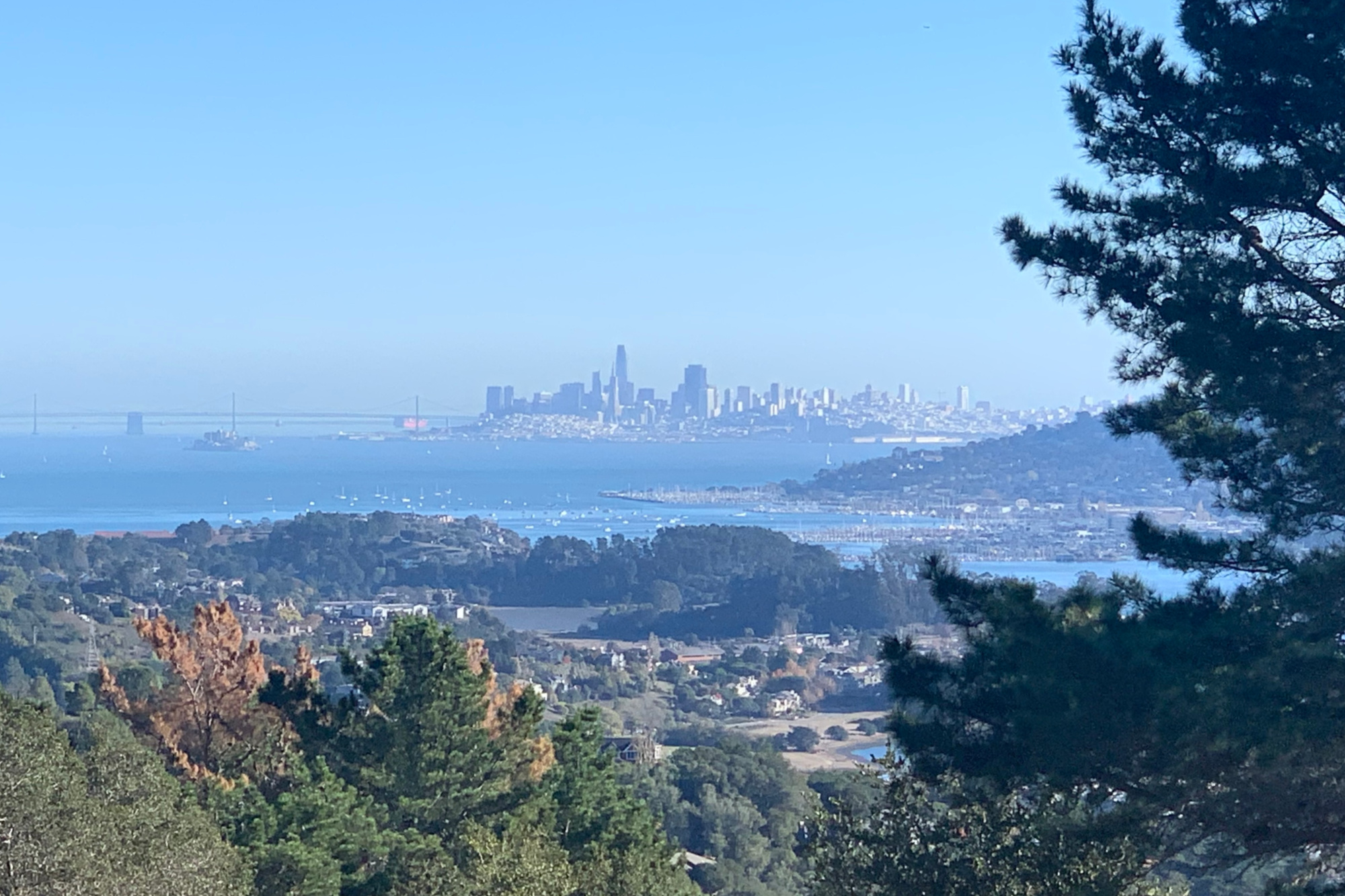
“Hiking it all lets you see the diversity of the environments and the seasons on the mountain,” Brent said. “The environments are not as similar as you might think—there’s redwoods, cypress, rocks, lakes and fields of wildflowers—and there are so many microclimates that move from fog to sun on a single hike.”
The pair ran into trouble on a few of the map’s more obscure trails; after spending a couple of different times scrambling over boulders or descending extremely steep spots, they worked hard to get the latest trail info before setting out, using the Komoot and AllTrails apps.
It took about 6-9 months for the Lauchles to color in all the hikes on the Tamalpais Trails’ map. They estimate it took them about 40-45 days of hiking 8-12 miles to reach their goal—not easy, to be sure, but not impossible for the legions of Tam lovers around the Bay Area.

“After all the miles we covered all over the mountain, we never finished a hike without taking a photo,” Jennifer said, whether it was of a view of the city or a blooming calla lily or the fog sitting on a bluff. And there were very few hikes where the Lauchles came home and resolved to “never do that one” again.
“Mount Tam is just a remarkable place,” said Jennifer.
How To Hike the 10 Best Trails on Mount Tamalpais
Convincing the Lauchles to produce this list of their favorite Mount Tam hikes was not easy. Each route they trekked had something unique to offer, be it a view, a body of water, a picnic spot or access to great post-trail tacos (Exhibit A: Joe’s in Mill Valley).
Translation? Pick a Tam hike; you can’t lose.

But after reviewing their picks, two takeaways emerge: First, the most popular hikes are popular for a reason: They’re awesome. Simply start your hike early if you want to avoid the crowds.
And second, many of these blockbuster hikes are on the southern side of the mountain, providing easy access from both the city and Highway 101.
But on a mountain riddled with trails, it is easy to combine, loop or spur on any of these paths to make them your own. In fact, Friends of Mount Tam created a Pantoll Quad Challenge to get your creative juices flowing: Four hikes that loop from the parking lot and cover 21 miles and 4,300 feet of elevation.
One last pro tip? Don’t forget $8 cash for parking at state park trailheads.

Check out the list below for the Lauchles’ picks of the most extraordinary day hikes on Mount Tamalpais. Finish them all, and you, too, will be on your way to conquering the Bay Area’s most popular hiking mountain.
Locals’ Favorite Hikes on Mount Tamalpais
4 miles out and back | 2.5 hours | Moderately challenging
Volumes have been written about Tam’s most popular trail: Steep Ravine. The gorgeous route starts at the Pantoll Ranger Station (bring $8 cash for parking) and descends 4 miles to the Stinson Tree and its lookout over the beach. The route just reopened in April following repairs needed because of winter storm damage, including rebuilding its famed ladders that move hikers along the creek and through the fern canyons. Need more of a challenge? Combine Steep Ravine in a loop with the Matt Davis and the Dipsea trails (below).

9.7 miles out and back| 6 hours | Challenging
The Dipsea traverses a similar descent to Steep Ravine and is similarly one of the most popular trails in the Bay Area if not the state. But this trail made famous by the Dipsea Race begins on the eastern side of Mount Tam in Mill Valley, ascends its infamous stairs to the ridgetop before descending to the sands of Stinson Beach: That translates to 2,700 feet of elevation gain if you do it out and back (!). Many hikers plan to stop when they get to Stinson after traversing multiple microclimates along the way and passing canyons of green moss, redwood thickets and lots of water. Take the bus back to Mill Valley or have a friend (or teenage son) pick you up in Stinson after rewarding yourself with lunch at the Parkside.

1.3 miles | Challenging
Diving into grove after grove of redwoods and some of the deepest forest on the mountain, the steep up-and-down of the Ben Johnson trail is officially a 1.3-mile trail that begins in the Muir Woods parking area. But most hikers connect Ben Johnson with Dipsea or another hike on the south side of Tam.

4 miles | 2.5 hours | Moderately challenging
Locals never have to reserve parking at Muir Woods. They simply park at Pantoll and follow the impressive Boot Jack Trail on the ridge above the park, dropping in as desired to see its ancient redwoods and throngs of tourists. (Technically, even if you skip the parking reservations, hikers should still pay the national park entrance fee.) It’s another Tam trail with considerable elevation change to keep the hardcore hikers happy.

1 mile | 30 minutes | Moderately challenging
Park at the Rock Spring or Trojan Point parking area and traverse the hillside to this epic swing and bench with massive, gorgeous vistas over the Pacific.

3.4 miles out and back | 2 hours | Moderately challenging
This lovely, short trail offers drop-dead views of the bay and the city and a shady trip with some decent elevation as it moves from Mountain Home Inn to the West Point Inn. The trip leaves you poised for a snack break at West Point Inn’s picnic tables and a lunch or dinner on the deck of Mountain Home Inn.
4.7 miles | 2 hours | Moderately challenging
Drive through the tony enclave of Ross and up along a creek to the trailhead and you might be tempted to stop in this verdant canyon before you start hiking. But a quick stroll up to the shores of picturesque Phoenix Lake is just a start to yet another gorgeous trail on the mountain. A reasonably tough climb up the pretty Yolanda Trail peaks at the top of Bald Hill, offering views of wildflowers and the top of Tam.

4 miles | 1.5 hours | Easy
This easy loop around picturesque Bon Tempe shares views of both humans and shore birds fishing—and one of the county’s tough-to-find bald eagles has been seen overhead too. This route can be combined with the Sunny Side Trail to double the length and triple the difficulty. The reservoir provides drinking water to Marin County so buying an annual parking pass for the Marin Municipal Water District lands can be convenient if you love the lakeside trails in this area.

2 miles out and back | 1 hour | Easy
Looking for an easy one that packs a visual punch? Head out from Downtown Larkspur on the Dawn Falls Trail. Parking is tough in Baltimore Canyon near the trailhead but grab a spot out on Magnolia Avenue and add some distance to the flat creekside stroll past redwoods, bays and madrone all the way back to the waterfall that runs in winter. Easy to combine this walk with Dawn Falls Loop for a longer, tougher walk.

6.4 miles one way | Moderately difficult
Marin teens spend many a golden hour watching sunset from “Bo Ridge.” The kids drive there via the north side of Mount Tam on the Fairfax-Bolinas Road. Hikers can start there or at the Pantoll Ranger Station at the south. Walk out and back as far as desired, with grassy hills, shady woods and non-stop ocean views all the way.
