An estimated 30,000 people are descending on San Francisco for the Asia-Pacific Economic Cooperation (APEC) summit this week, world leaders such as President Joe Biden and Chinese President Xi Jinping among them.
With that influx of VIPs comes a massive security apparatus that will affect people traveling across San Francisco. Authorities are shutting down a swath of Downtown, rerouting bus and metro lines, and even closing two lanes of the Bay Bridge.
The evolving security situation has led to growing concerns by local residents and businesses closest to the transit and road closures, and many San Franciscans are confused about how best to avoid disruptions and go about their business. To help people understand the extent of the temporary modifications and what they mean, The Standard has put together an FAQ to guide you through APEC week.
Where exactly is the main security perimeter for the event, and how long will it be in place?
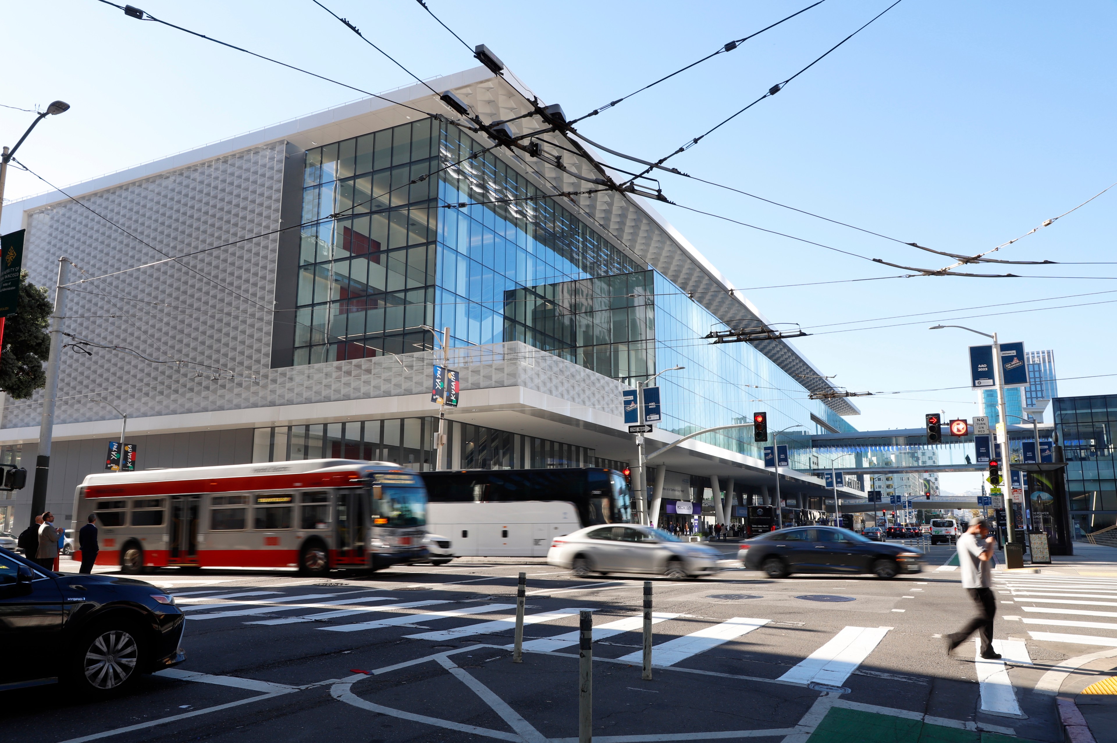
The main venue is the Moscone Center in the South of Market neighborhood.
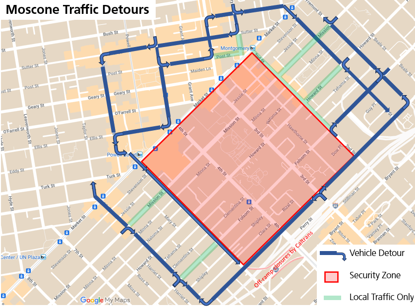
From 10 p.m. Tuesday to Saturday, local traffic into the security perimeter—for those who live or work in the area bounded by Second, Market, Fifth and Harrison streets—will be allowed only through specific paths after a security sweep and inspection.
Pedestrians and bicycles not heading into the security perimeter will be routed around the area. Vehicles that do not need to enter the perimeter for residential or business purposes will not be allowed in.
Most vehicles traveling south from Nob Hill and Chinatown will be rerouted to either Mason Street to the west or Bush Street to First Street to the east. Drivers traveling south of Market Street from the Embarcadero will be pushed north at Fremont Street or south at First Street to avoid the security zone. Southwest of the perimeter, vehicles will be routed onto Sixth Street for north-south travel and Harrison Street for east-west travel.
Fencing and pedestrian and vehicle checkpoints will be in place between Wednesday and Saturday, with barricades erected after a security sweep on Tuesday night. Minor street and sidewalk closures for the staging and removal of equipment may also be in effect through Sunday.
What if I live, work or want to visit a business inside the security zone?
The SoMa security zone will be divided into two sections, shown in green and red on the below map. Pedestrians may enter the outer green zone without being screened or presenting identification. But starting Wednesday, anyone entering the green zone in a vehicle will need a valid reason, including being a resident, event guest or patron of a business within the perimeter.
No street parking, transit or taxis will be allowed within the security zone, though paratransit will be able to enter. Bicycles and scooters will be allowed inside once screened.
Starting Wednesday, the inner red zone will only be accessible to APEC attendees or patrons of a business inside the perimeter. All entrants to this area, including pedestrians, will be screened. Pedestrian screening checkpoints will be at Howard Street near Fifth Street on the west side, via Yerba Buena Gardens on Mission Street on the north side and Folsom Street near Hawthorne on the east side.
Eligible vehicles will be able to enter the perimeter via three checkpoints. Two are on the west side of the zone, at Fifth and Mission streets and at Folsom and Fifth streets. One is on the eastern side at New Montgomery and Jessie streets.
Vehicles will be subject to searches and screenings, including by K-9 units. Between Wednesday and Saturday, residents will be required to show an ID with their address to drive to their homes. If they don’t have an ID with a current address, they will be able to show secondary proof of residence, like a utility bill or a lease.
To reduce potential delays by emergency vehicles that would otherwise have to be screened, there will be emergency vehicles prepositioned inside secure areas to lessen response times if needed.
Deliveries made to either red or green zones after 8 p.m. Tuesday must be screened at Pier 27 by the Secret Service, after which they will be sealed and must go to the site they are delivering to without taking on additional cargo.
Hot food delivery will not be allowed inside red zones unless carried on foot and rideshare services such as Uber or Lyft will not be allowed, according to Secret Service Assistant Special Agent-In-Charge Jermy Brown.
Food delivery and rideshare vehicles can stage at two locations one block away from pedestrian access checkpoints, although where those areas will be are still being sussed out, Brown said.
Employees of businesses can show a badge or work ID card to be allowed in with their vehicle. Pre-registration is not required, and residences and businesses will be generally accessible, barring a major security event.
Protesters will also be allowed to access to green zone, but will not be able to access red zones.
While pedestrian access into red zones will require screening, agents will not ask about citizenship status for pedestrians entering secured areas or people inside vehicles accessing green zones.
“We’re to secure everyone’s safety,” Brown said. “We’re not here to check peoples’ [immigration] status.”
Are there other security perimeters around the city?
In Nob Hill, a perimeter around the Fairmont Hotel will be established on Monday night, bordered by Clay, Taylor, Pine and Stockton streets. Pedestrians trying to enter the security area will be required to enter via a checkpoint at Huntington Park.
Vehicles going into the area will be subject to checkpoints at either California and Taylor streets in the west or Washington and Powell in the north. This perimeter will likely be dismantled late Saturday, though its effects may continue into Sunday.
Because of a major party with President Joe Biden and other world leaders at the Exploratorium, detours and street closures around that museum will begin at noon Wednesday, with the Embarcadero closed between Pier 9 and Pier 27. Local traffic will be allowed on Front Street and Broadway, but most vehicles will be detoured via Battery Street, Broadway and Sansome Street. This perimeter will end late Wednesday.
Street closures and detours around the Legion of Honor will begin at noon Thursday. Clement Street will be closed between 34th and 38th avenues, except for people who live or work between these streets. The 18th-to-46th Avenue Muni bus line will be rerouted during this time. This perimeter will end late Thursday.
A controlled pedestrian-only zone will be set up around the Asian Art Museum for an APEC CEO Summit event Tuesday.
What about parking?
On-street parking will be barred within all security zones. Emergency no parking signs will go up around the city. Vehicles that are parked in violation of emergency no parking signs will be ticketed and towed. Notices will be posted at least 72 hours in advance of the restrictions being put in place.
There are no private residences inside the red zones surrounding the Moscone Center and Fairmont Hotel and any parking garages used by residents in secured areas are inside green zones, Brown said.
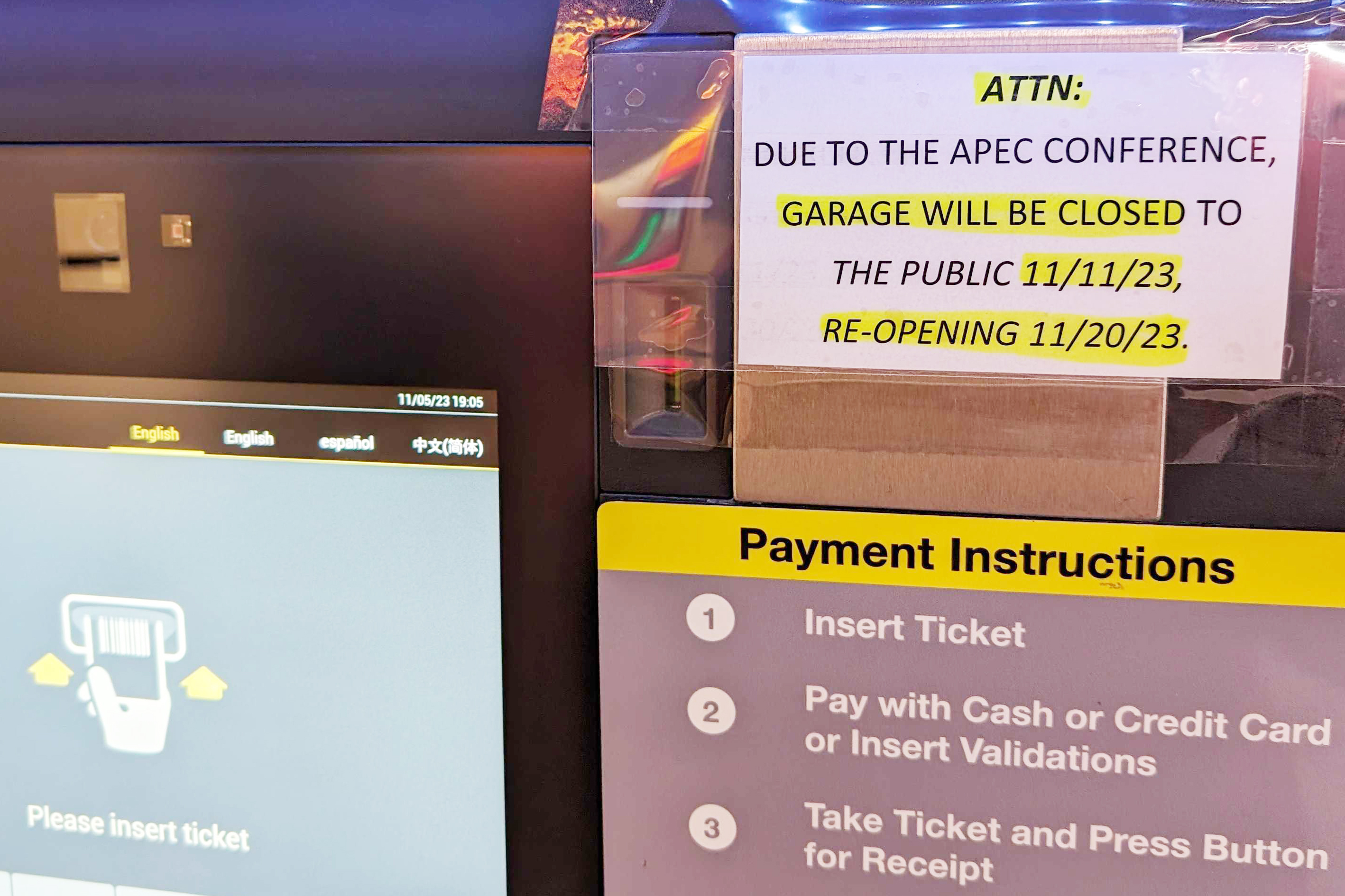
The Moscone Center Garage and Fifth and Mission/Yerba Buena public garages will be closed until Sunday. The SFMTA-owned parking garages close to the main event that will remain open during APEC are the Ellis-O’Farrell, Union Square and Sutter-Stockton garages.
What are the freeway impacts of APEC?
On the Bay Bridge, the rightmost lane of I-80 westbound and the leftmost lane of I-80 eastbound will shut down from Tuesday at 5 a.m. to Friday at 9 p.m. to provide access for California Highway Patrol.
The I-80 eastbound off-ramp at Fourth Street will be closed from Wednesday to Friday from 5 a.m. to 9 p.m. daily. The last eastbound San Francisco exit before the Bay Bridge will be at Seventh Street instead of Fourth Street. The I-80 westbound off-ramp at Fifth Street will be closed from Wednesday to Friday from 5 a.m. to 9 p.m. daily. Drivers planning to get on the eastbound freeway near the Moscone Center should use the Eight Street on-ramp. Drivers planning to get off the freeway should use the Fremont Street off-ramp.
Additionally, the northbound U.S. 101 Dana Bowers Vista Point off-ramp north of the Golden Gate Bridge will be closed from Tuesday to Saturday.
Can I access the Moscone Center?
Credentials are required to enter the Moscone Center. Venues directly involved with the APEC summit and APEC CEO Summit will be locked down with unscalable fencing and be inaccessible to anyone without a credential.
Can I access the Yerba Buena Gardens?
No, the city park will be inaccessible to the public unless are credentialed for APEC events or they are traveling to a specific business or residence. The adjacent Yerba Buena Center for the Arts will also be temporarily closed from Monday through Sunday.
Can I access SFMOMA?
Barring unforeseen restrictions, SFMOMA aims to be open during regular business hours during APEC. Only walk-up, on-site tickets will be available Tuesday through Friday.
Will Muni Metro, cable car or bus service be disrupted during APEC?
Yes. In fact, Muni began rerouting service a full two days earlier than planned.
“Muni is no longer able to serve stops in exclusion zones,” the agency announced on X Friday. “Muni service is passing blocked stops. For safety, riders should not stand in the street as Muni buses will not stop. Conditions are changing rapidly due to street impacts.”
ATTN: Muni is no longer able to serve stops in exclusion zones. Muni service is passing blocked stops. For safety, riders should not stand in the street as Muni buses will not stop. Conditions are changing rapidly due to street impacts. Details here: https://t.co/EjSRws5r3U
— SFMTA (@SFMTA_Muni) November 11, 2023
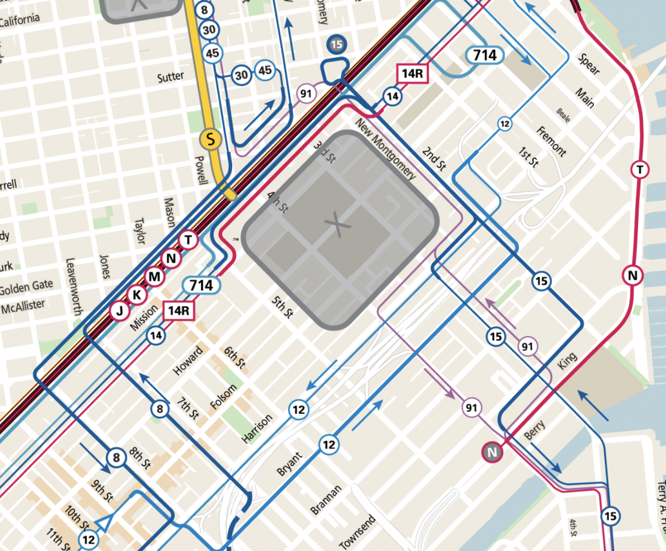
In SoMa, bus lines will be rerouted around the security perimeter around Moscone Center, which is bordered by Second, Market, Fifth and Harrison streets. Ambassadors will direct transit riders to temporary bus stops outside the zone. The 30 Stockton and 45 Union-Stockton will only operate north of Market Street.
See a full list of bus lines being rerouted here.
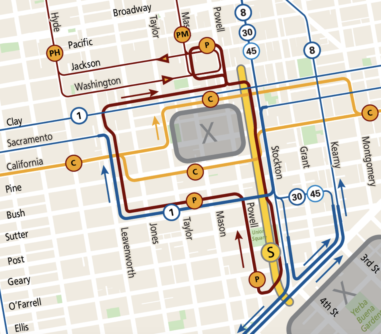
Multiple Muni lines will also be rerouted around the security zone in Nob Hill. The below map shows how bus lines will be rerouted, and a full list of changes is on this page.
Cable car stops are closed on the Powell-Hyde and Powell-Mason lines from the Market Street turnaround up to Clay Street. Riders will be able to take the cable cars between Washington Street and Bay Street on the Powell-Mason Line and between Washington Street and the Hyde Street turnaround. A bus substitute will provide service to stops along Powell Street from Jackson to Ellis streets.
The entire California Line will be shut down during the event, with a substitute bus serving the entire route.
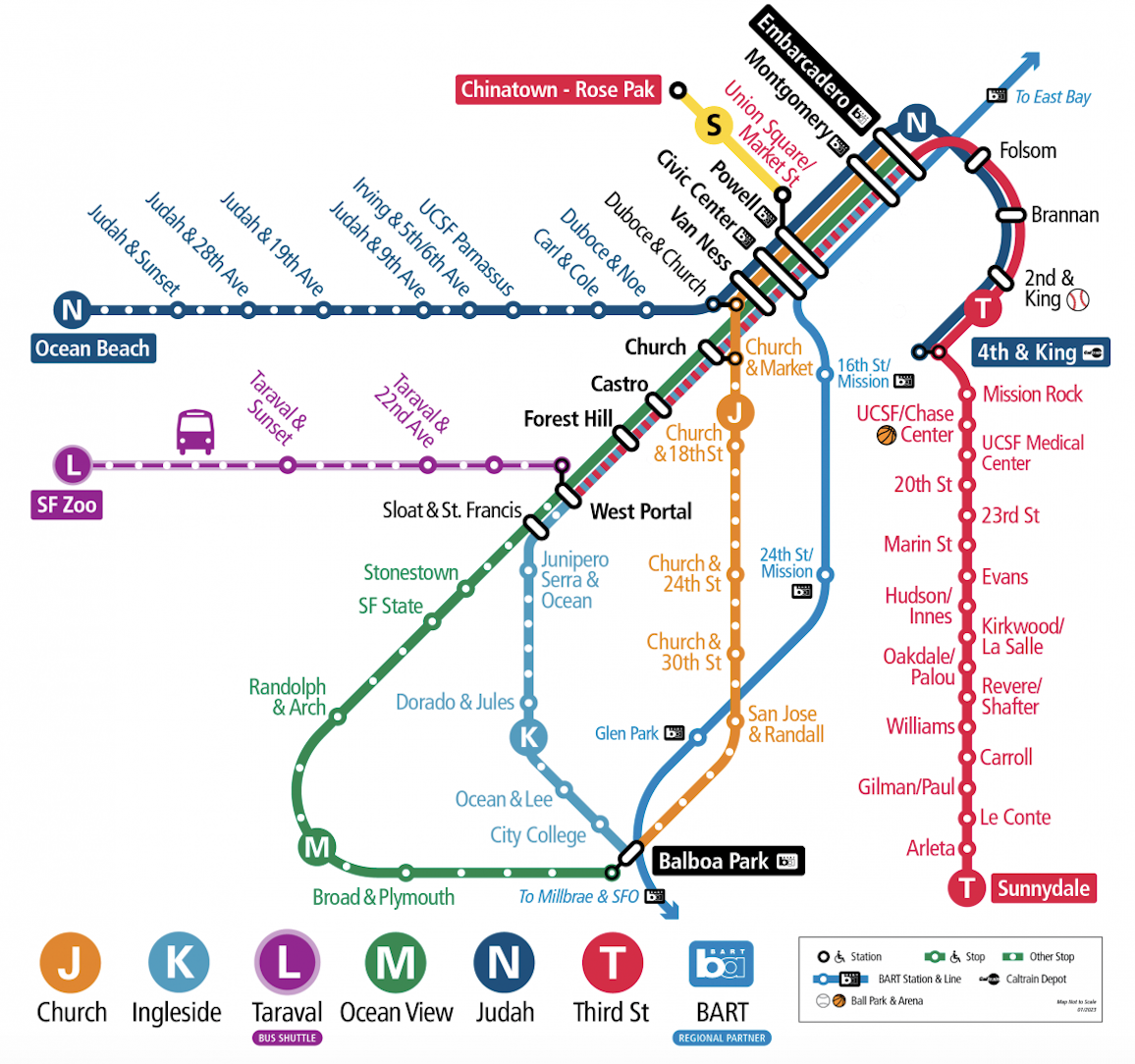
There will be no Muni Metro service provided to the Fourth and Brannan or Yerba Buena-Moscone Station. Trains on the T-Third route will be rerouted to its previous route instead of entering the new Central Subway route. A Muni Metro shuttle train will operate every five minutes between Chinatown-Rose Pak Station and Union Square-Market Street Station.
Will ferry service be disrupted during APEC?
Representatives for the Water Emergency Transportation Authority and Golden Gate Transit said they don’t expect any disruptions to San Francisco Bay Ferry service.
Will BART or Caltrain service be disrupted during APEC?
BART and Caltrain schedules will remain the same, and no stations will be closed.
How can I stay up-to-date with new transit changes?
SFMTA has an APEC resource page here, with the option to sign up for real-time email or text alerts. The city of San Francisco and the U.S. Secret Service also have a comprehensive map available online here, where updates may be posted.