In the oldest parts of San Francisco, the streets are narrow, the grid is idiosyncratic, and everything is hills. There’s a reason the city’s most famous cars get dragged along by cables. Topography, infrastructure, and self-image have long conspired to keep the automobile from being the people’s choice for getting around.
But despite that legacy, San Francisco may be on the verge of becoming something else entirely: a car city.
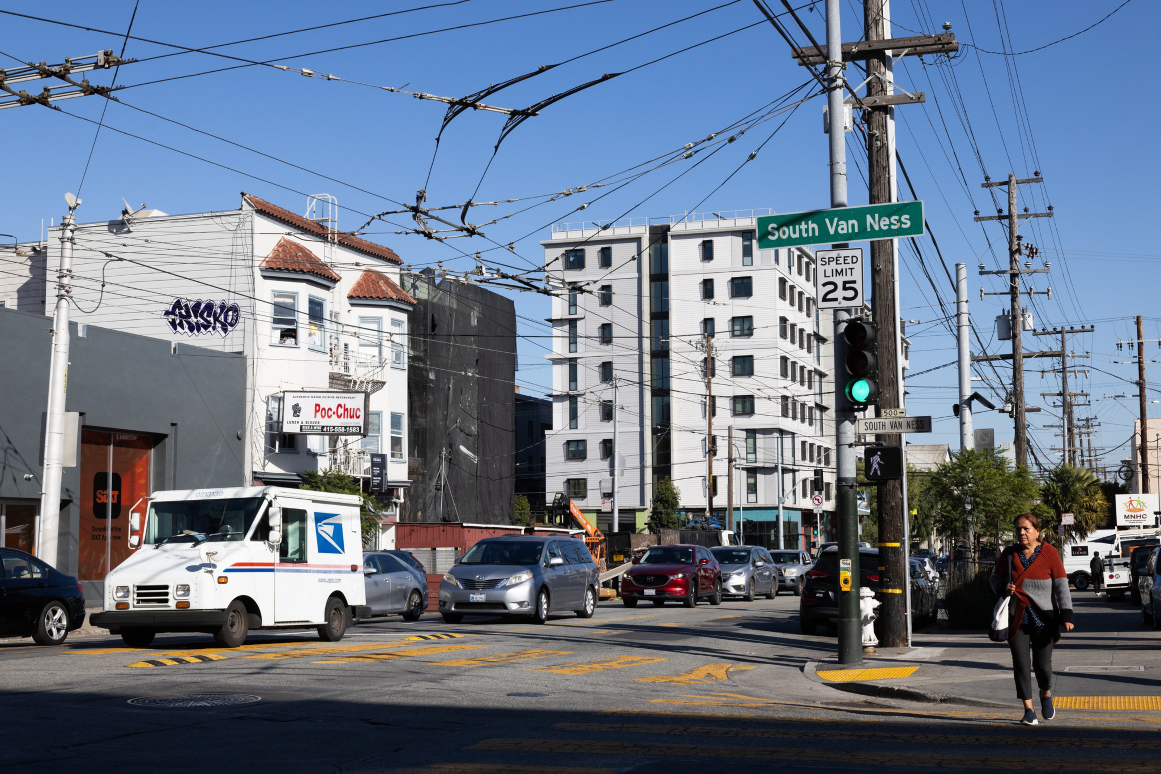
The data is mounting: Car use is back up from pandemic dips to 2019 levels, transit use is at a historic low, and the parts of the city most conducive to private automobiles (the west, southeast, and north sides) are thriving, while once-busy, denser areas like downtown are stagnating. Efforts to redesign streets to force cars to share with bikes, people, and buses seem stalled. The mayor wants to reopen Market Street to Waymo and might do the same soon for Uber and Lyft.
Forget the supposed war on cars: In San Francisco, the cars are winning.
And once car dependence starts, it tends to keep going. Pretty soon, motorists become a voting bloc; witness the contentious effort to recall Supervisor Joel Engardio over his role in converting a section of the Great Highway to a park. Drivers begin demanding that the city prioritize cars, and a city designed for cars makes cars more appealing. More drivers beget more driver-friendly policies, which encourage more driving. It’s a self-reinforcing cycle — a vroom loop, if you will.
And the more that starts spinning, the more San Francisco becomes the thing it claims to oppose.
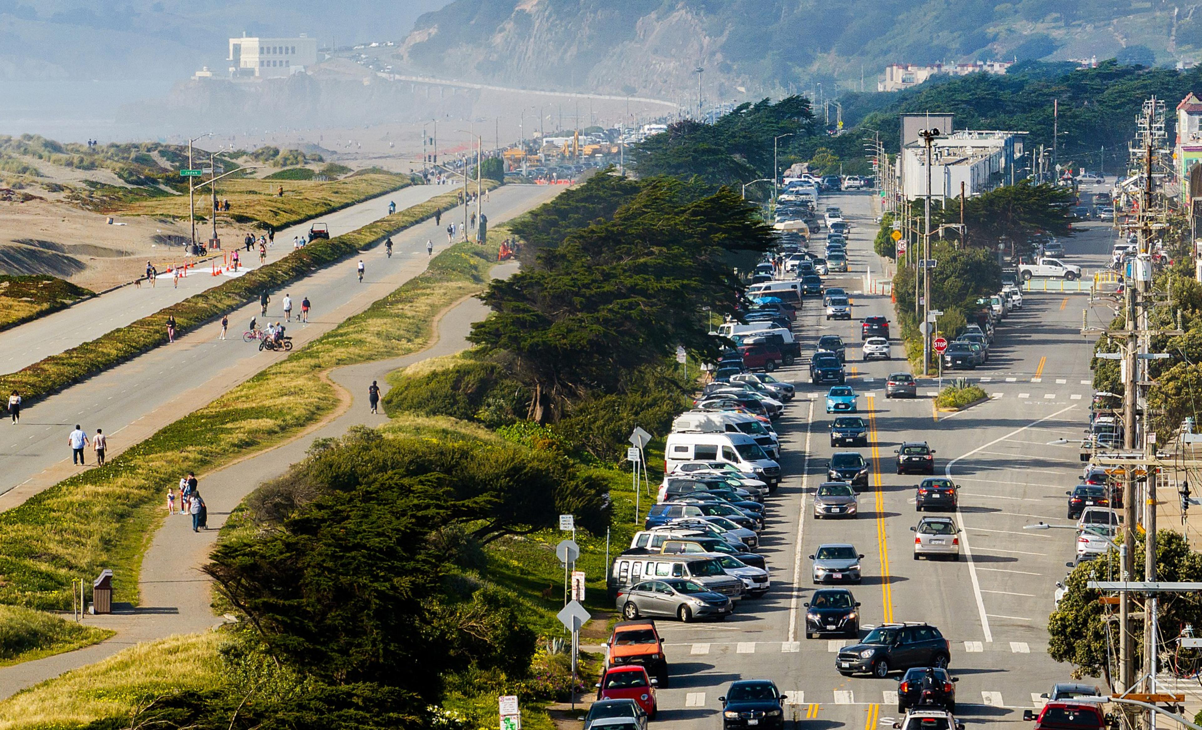
Car use is up, transit is down
In many ways, cars contradict San Francisco’s self-image. We are the capital of ornery progressivism and bike-riding outdoorishness. We love trains so much that we run restored trolleys from other cities on our tracks. That’s hardcore. Meanwhile, we are opposed to everything cars stand for: They emit carbon and fuel climate change; add to noise and light pollution; create public nuisances from sideshows to double-parked DoorDash drivers; and, most critically, they kill a lot of people.
But the city’s affinity for public transit, bikes, and walking has hit some speed bumps. Urbanites choose how they get around based on an intricate calculus: What’s easy? What’s fast? What’s comfortable? What’s affordable? If every other way to get around is less convenient and reliable, and forces people to confront the raw edges of urban life, then the car starts to look like a solution.
That’s where we’re at. Our public transit system was built to move people to and from downtown, but because downtown is commercial, it’s vulnerable to economic cycles. It was full of technology workers, but Covid nudged those jobs to remote ones. It was full of big stores beckoning regional shoppers and tourists, and then those shoppers got scared away by crime and misery and captured by Amazon.
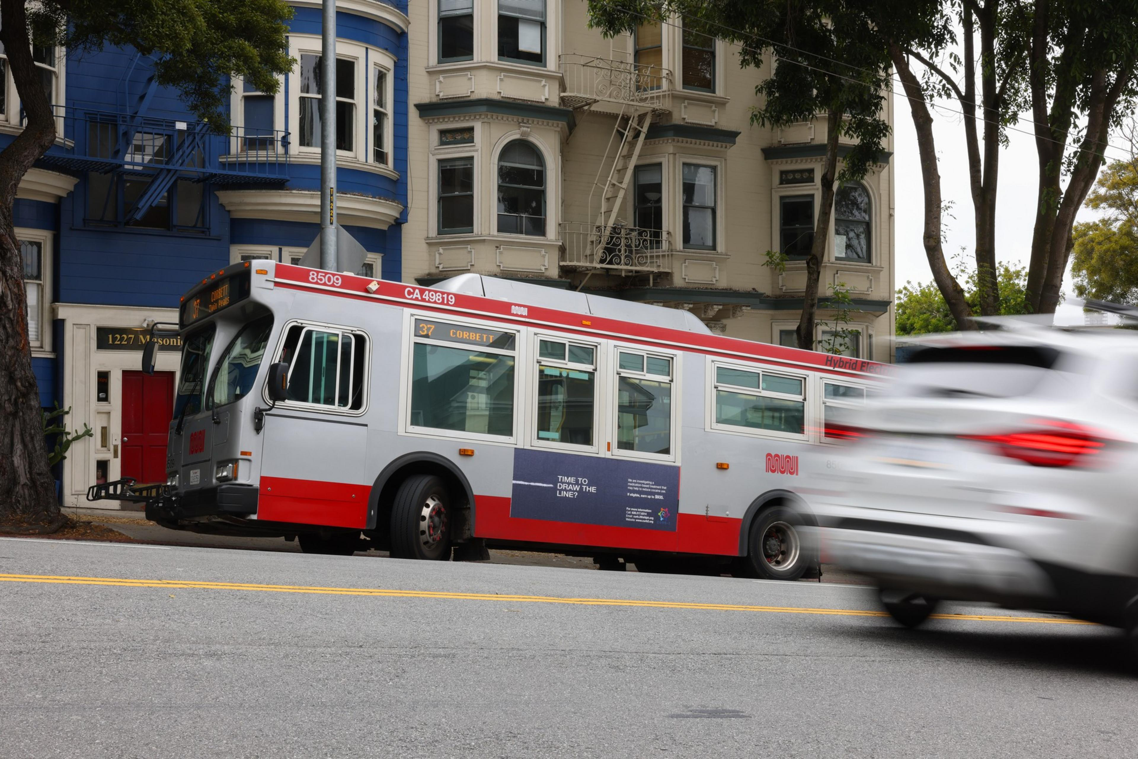
Per capita, San Franciscans still use public transit more than residents of any other U.S. city except New York. But after Covid, transit use declined more here than anywhere (opens in new tab) else. In May 2019, BART turnstiles counted an average of 412,165 people every weekday. In May 2025, that number had plummeted to 170,293. Caltrain is carrying fewer than half as many people as it did in 2019.
The story with city buses is less clear but still shows declines. Muni ridership peaked (opens in new tab) right around the dot-com bubble at the turn of this century — topping off at 754,000 average weekday riders. It stayed in the high 600,000 range until the pandemic. In 2024, (opens in new tab) four years after Covid, weekly average Muni ridership, though rising, was at 486,000.
Other cities’ downtowns and transit systems recovered far better. “But San Francisco struggles, comparatively,” says Yonah Freemark, a researcher at the Housing and Communities Division at the Urban Institute. “It has not really expanded its transit system and has not been able to attract employers downtown, and it is a wealthier region with less of a working-class need to use transit.”
Car use, meanwhile, is back. For all the efforts the city has made to get people out of automobiles — erecting bike lanes and slow streets, launching bike share programs, and closing off entire boulevards to traffic — car ownership has held steady for decades, at around 70%. San Francisco drivers put a total of 9.4 million miles (opens in new tab) on their cars every day, just a touch shy of the same stat 25 years ago.
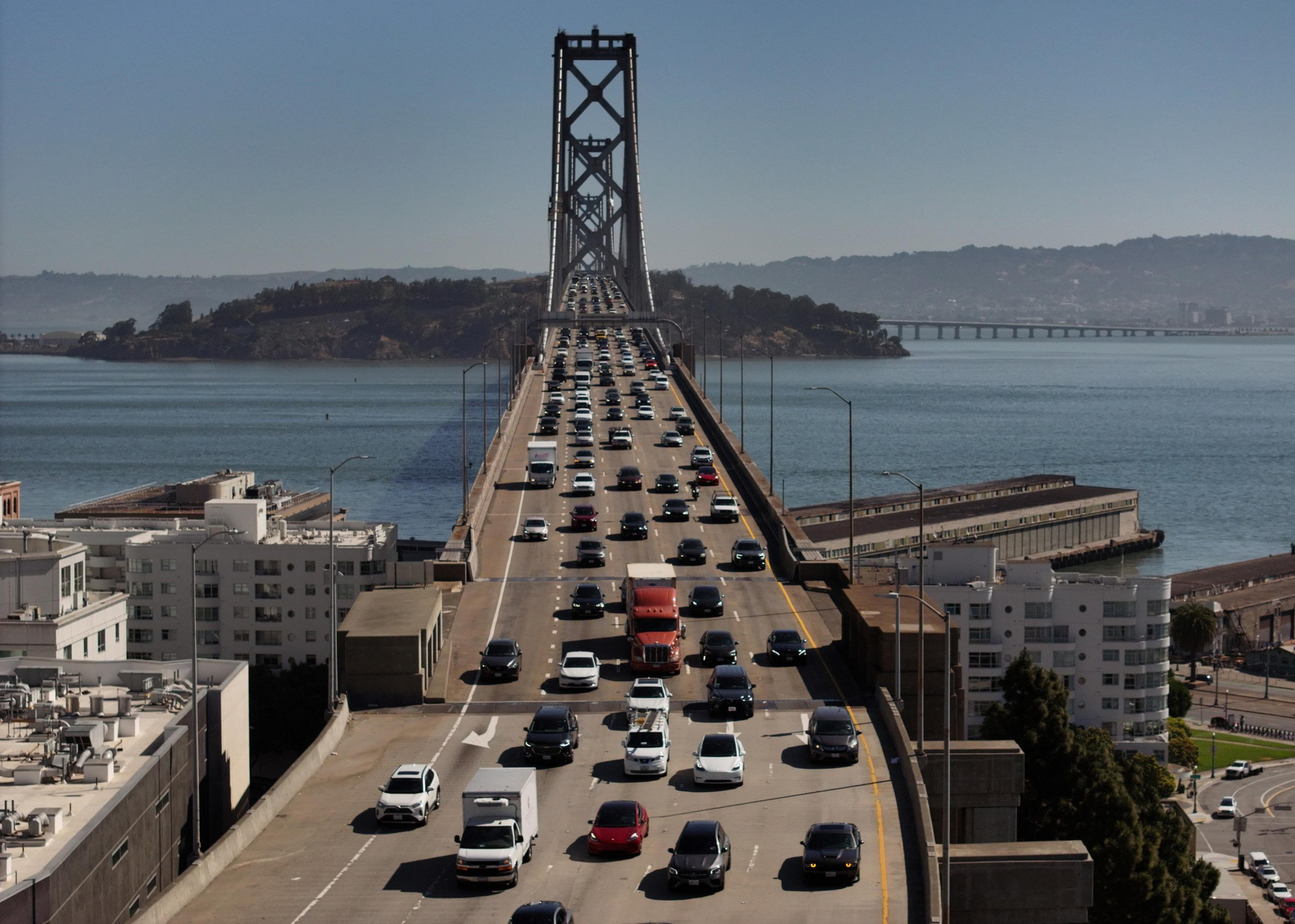
According to a survey by the SF Unified School District (opens in new tab), 49% of all school trips are by car. In May, newly installed speed cameras captured nearly 100,000 people speeding (opens in new tab) at busy intersections around the city. And car commuters are still commuting: Bay Bridge tolls regularly exceed pre-pandemic levels (opens in new tab), and the other bridges are close.
That’s before you consider the many cars operating as ride shares or private taxis. Whether Uber, Lyft, and Waymo are replacing transit rides with car rides isn’t clear, but it seems likely. The best analysis (opens in new tab) is from 2020, pre-Covid and before Waymo came to town, so it’s not especially helpful. These services probably worsen congestion and pollution, though some evidence suggests they complement transit (opens in new tab) use in certain corridors. Either way, they add more cars to the mix. Even robot cars, though exciting and futuristic and probably safer than human-driven ones, are just cars.
“If you plan for people and places, you get people and places. If you plan for cars and traffic, you get cars and traffic,” says Marcel Moran, a faculty fellow at the NYU Center for Urban Science and Progress. “If you’re in the avenues, the Richmond or the Sunset, the vast majority of the public right-of-way has been reserved for car movement and car storage.”
This divergence shows up most clearly in the city’s commercial landscape. The most vibrant recreational and shopping nodes are served best by car and transit, rather than transit alone. When it comes to shopping, citywide sales tax revenue (opens in new tab) has fallen 28% since 2020. Downtown took the hardest hits (opens in new tab): The Financial District is down 38%, South of Market is down 42.6%, and Mid-Market dropped more than 80%. San Francisco Centre, the former Westfield Mall downtown, has lost nearly all of its tenants, and its owner gave the keys back to the bank.
Meanwhile, in Japantown — where parking is relatively easy and transit lines are plentiful — every storefront is full, and the walkways are shoulder-to-shoulder. Japantown is actually bringing in more sales tax revenue than it did in 2019; it also sits atop the biggest and most profitable (opens in new tab) SFMTA-owned parking lot in the city.
Similarly, Stonestown Galleria on the west side is the city’s hottest shopping, dining, and entertainment destination, supported by Asian restaurant chains and a vast late-night gaming and entertainment center. It’s also a commercial harbor surrounded by a sea of free parking — and, like Japantown, it’s outperforming its 2019 sales tax numbers.
Yes, these neighborhoods benefit from nearby transit — but in a city drifting toward car reliance, ease of driving appears to be a decisive edge.
The past crashes into the present
San Francisco’s far-flung neighborhoods seem car-dependent now — but they were designed for streetcars.
In the 1890s, the cable car system (opens in new tab) spanned the city, from the Mission to Fisherman’s Wharf and from the Ferry Building to Golden Gate Park. Fifty years later, a spiderweb of light rail lines (opens in new tab) covered the East Bay, crossing the then-new Bay Bridge (the lower deck was reserved for trains) to reach the old Transbay Terminal, where it met a dense meshwork of trolley lines that extended all the way to, I kid you not, San Mateo.
But in the postwar American city, the main characters don’t glide along rails; they weigh two tons and speed along wide, banked avenues at 40 miles an hour. Sure, San Francisco said no to more freeway construction and even tore down some of the ones that did get built. But though righteous, the “freeway revolts (opens in new tab)” weren’t born of some unified vision of European walkability, or even in defense of the poorer, non-white neighborhoods where freeways tended to be built. It was a typically San Franciscan resistance to change — the same reason there isn’t a BART line to the beach or dense, infill-type housing citywide.
San Franciscans are fundamentally conservative about anything that remodels their mental map of the city. That goes double when the changes to the map impact cars — and specifically, where we’re supposed to park them. The darkest fears of NIMBYs don’t revolve around falling home values or rising urban density — they’re over losing parking.
“Parking policy is the most boring thing to read about,” says Jason M. Henderson, a geographer at San Francisco State who studies mobility. “But it’s also the most emotional issue, when it comes to somebody’s parking space. Or what they think of as their parking space.”
Another powerful motivator for motorists: Cars shield them from the parts of the city they’d rather not see, and the people they’d rather not cross paths with. By comparison to transit, cars feel like a technological cocoon that lets riders avoid dealing with anyone on the street having a mental health or substance abuse crisis. They’re not just private but safe.
But this is an illusion, of course. Cars aren’t safe. Forty-two people were killed in auto collisions in San Francisco in 2024; another 21 have died so far this year (opens in new tab). In fact, cars have become more dangerous (opens in new tab) to everyone outside them. From 2000 to 2020 (opens in new tab), people killed inside cars went down 20%, while pedestrian deaths rose 30%, in part because the average American vehicle has become larger and heavier. At the same time, the marketing shifted: Cars were once sold as freedom; now they’re sold as fortresses (opens in new tab).
That Ford truck may seem ruggedly individualistic, but it’s also wimpy. It magnifies how its driver perceives the real and imagined dangers of the Big City. A small study in 2013 hinted that people in cars thought neighborhoods were poorer and scarier (opens in new tab) than they did if they were walking in those same places.
So, driving makes you feel safer, but it also makes you think the city you’re driving through is more dangerous. Which, of course, makes you want to keep driving.
Breaking the vroom loop
In spite of all the forces pushing San Franciscans into cars, the vroom loop isn’t inevitable. BART ridership rose 6.5% in the first three months of 2025; Muni was up about 4%. Ferry ridership is up by double-digit percentages. Electrification of Caltrain (opens in new tab) has resulted in a 60% jump in ridership, better service, and a look and feel that’s practically European.
The city closed the Great Highway and JFK Drive to car traffic. Market Street’s closure to private cars didn’t come with the other improvements needed to make it a great public space, but it’s still (mostly) in effect. Since the 1990s, San Francisco has built more than 460 miles (opens in new tab) of bike lanes. Many Covid-era “safe streets” remain in place.
Sure, the Municipal Transportation Agency canceled the Residential Traffic Calming Program (opens in new tab) that let people request speed bumps and center medians to slow cars, but it did it because the program was too popular. People loved it to death. New York City has closed most of the outside-dining parklets that opened over the past few years; SF has not.
“SFMTA would never call it this, but a really thriving outdoor dining program is a parking removal program,” Moran says. “And the Board of Supervisors passed a resolution to remove parking spaces in front of bus stops.”
So if you squint, you can see good news. Even the mall renaissance has nuances. Stonestown and Japantown likely owe some of their success to transit. Stonestown has light rail and a university — San Francisco State — in its backyard. The buses that go to Japantown are packed and are among the most ridden bus routes in the U.S. Since the pandemic, teenagers have ridden SF buses for free, and they use them to go to the mall. You know — like teenagers!
There are other plus signs: The forces in favor of building more homes around the city are ascendant, and thanks to a bunch of recent changes to the law, those new buildings won’t have huge amounts of parking. Denser residential neighborhoods keep housing costs down, which leads to a need (and demand) for a variety of transportation options. When cars are less convenient and more expensive, people take buses. The transit system makes more money and improves. Traffic congestion eases. The vroom loop becomes a zoom loop.
Paris did it (opens in new tab). San Francisco can, too.
“The 10,000-foot view is positive signs for people-centric, non-car, walking, biking, and transit,” Moran says. “But it’s against the backdrop of a city whose infrastructure in the public right-of-way privileges the automobile.”
This all hints at a coming détente. Daniel Lurie won the mayor’s race in 2024 by forging a coalition between the dense, non-car central city and the west side, where car ownership is highest (opens in new tab) and most of the driving happens. Maybe that’s the future. Lurie didn’t campaign on transit and safe streets, but he has deputies who know how to build them. Even the most ardent transit nerd wants a city that has cars; even the most car-brained stalwart of Ingleside Heights wants to be able to ride BART into the Mission.
San Francisco doesn’t have to become a car city. But if it drifts any further, the vroom loop will become a traffic roundabout with no exit.