About 100 miles south of San Francisco lies one of the most beautiful places in a beautiful state. Of all of California’s scenic highways—State Route 120 through Yosemite National Park, U.S. 395 behind the spine of the High Sierra, the 405 through Sepulveda Pass with nobody else on it—perhaps nothing compares to the stretch of the Pacific Coast Highway from Carmel-by-the-Sea south to Santa Barbara.
And the most beautiful section of this is Big Sur, which has been cut off from the south for the past 11 months. On Jan. 8, during a period of atmospheric rivers, an enormous movement of earth at a spot called Paul’s Slide near the town of Lucia buried a two-mile segment of the coast highway. The landslide some 40 miles south of Big Sur’s lodges and redwoods forced not only the highway’s closure but, eventually, also required workers to terrace the slope and move the roadway itself.
The state’s transportation agency, Caltrans, estimates that the road, technically State Route 1 and often signed as the Cabrillo Highway, will fully reopen in late spring or early summer 2024, at the cost of nearly $100 million.
That’s assuming, of course, that this winter is kinder than the last one, or the one two years before, or one in 2012 that closed the same section, or the very wet winter of 1983-84 or the many destructive episodes before then that dislodged massive quantities of boulders and crud from the Santa Lucia Mountains, undoing the work of seismic uplift and slowly recontouring the Monterey County coast itself.
The region is accustomed to catastrophe, having endured floods and fires and even a period in 2017 when separate slides cut Big Sur off in both directions for about five months. But after almost a year of trucks hauling away debris and later bringing dirt in to backfill the excavation, many of the family-owned businesses that cater to visitors in and around Big Sur are staring down the possibility that their isolation may only grow.
Where the Road Ends
Big Sur is both a region and a town. And truthfully, it isn’t a town as much as an unincorporated constellation of resorts and businesses strung along the highway where it bends inland from the coast and follows the river of the same name. For many residents, seclusion is the primary attraction.
“You only come to the road when you have to come to the road,” said Sunyata Marlene Cresci, a plein-air painter whose works hang in a gallery occupying a former carn barn and school at Loma Vista, known as Big Sur’s cultural hub.
To her, people will always be drawn to Big Sur, no matter how hard it is to get there. They’re drawn to the feminine curves of the landscape, she said. Or to the smell of it.
“Lots of people say, ‘Oh, we’re coming from San Diego. Yes, of course, we have to drive up and go around Carmel,’” Cresci said. “Oh, you suffered through being in Carmel? No problem!”
Officially, Caltrans remains committed to clearing and reopening Pacific Coast Highway this time, and next time, and the time after that, no matter the cost. For now, it’s what Caltrans District 5 Public Information Officer Kevin Drabinski calls the “most beautiful cul-de-sac in the world.”
The closure at Paul’s Slide has so far required the removal of 500,000 cubic yards of material, which would be a pile of debris measuring roughly 550 feet on all sides. Downtown San Francisco’s One Rincon Hill, the residential tower that looks like a Sharper Image air purifier pressed almost against the Bay Bridge, is about that tall. If it were just as wide and just as deep, that would approximate the amount of rock, dirt and mud that slid down the slope.
Drabinski points out that no other slide last winter—and they happen all the time—involved more than 30,000 cubic yards of earth.
For now, the highway simply terminates at a newly striped turnaround south of Lucia. When The Standard visited the spot, about 180 road miles south of San Francisco, no earth-moving equipment was even visible. Nor were the crews whose work pauses constantly as engineers reassess the stability of the slope.
By day, a single guard is stationed there to keep out the curious and calm the drivers who either ignored or, if they aren’t English speakers, weren’t able to read the numerous signs that warn about the closure down the road, and who didn’t use Google Maps, either.
The guard said on occasion, cyclists will try to find trails to get through. At this time of year, he’s there from before sunrise until after sunset.
By night, there’s no one.
Drivers hoping to go from Lucia to, say, Hearst Castle in San Simeon—about 40 miles down Highway 1 in more normal times—currently have to double back nearly to Monterey, detour inland to U.S. 101 and approach San Simeon from the south, adding three hours and more than 150 extra miles to the trip.
Rugged Independence
For Rick Aldinger, general manager of the Big Sur River Inn, the river is the source of the region’s magic. Every time a guest exclaims how beautiful Big Sur is, he asks them the same question: Did you get a chair and sit by the river?
“So many people are like, ‘There’s a river here?’” he told The Standard. “Time and time again, when they see the lawn and the chairs and the river, they visibly gasp.”
Aldinger expects Highway 1 to close briefly every winter, and whenever it does, business drops 30% almost without fail.
“We expect it to happen for brief periods of time, maybe half a day or three days,” he told The Standard. Drawing out the word for emphasis, he added, “Maaybe five or six days.”
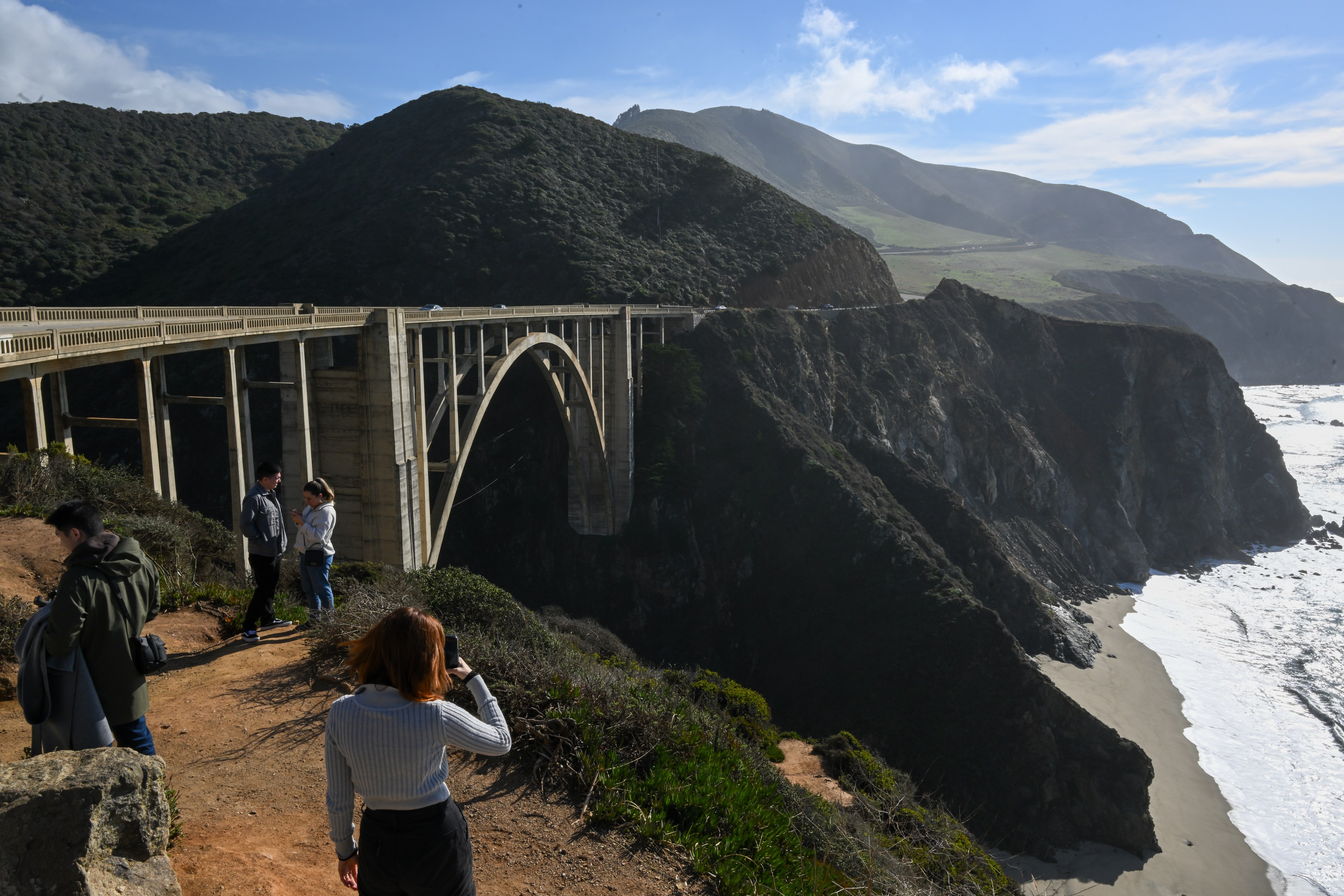
The protracted nature of the 2023 closure ate into the high season, compounding the problem for the region’s oldest resort—which opened in 1932, around the same time as the famously photogenic Bixby Bridge.
“All of the businesses in Big Sur are very seasonal by nature, and we know we have to do well in summer to be able to make it through the following winter,” Aldinger said. “And we didn’t have that opportunity this summer.”
Although Aldinger will be retiring shortly after 17 years of “the most beautiful commute on the planet,” he’s confident that the community will prevail, not only because of the locals’ resilience, but also because the remoteness is what attracts people—residents and guests alike—to Big Sur in the first place.
The Big Sur River Inn’s owner is about to hand over the reins to his son, assuring Aldinger that the property will remain in the family rather than go to some hospitality conglomerate. That’s what happened to the 59-room Alila Ventana Big Sur resort, among Big Sur’s most luxurious. In 2021, it sold for $148 million to a subsidiary of Hyatt Hotels only to flip again months later for $150 million, a record price per room in Monterey County.
At the nearby Ripplewood Resort’s cafe, 29-year-old server and Big Sur native Tito Paz has been dealing with the road’s quirks all his life.
Having grown up on the Ventana, where his parents worked, Paz told The Standard that when he was in high school, there was a period when the road closed, forcing students to go on a twice-daily, 15-minute hike.
“We had the elementary school bus take us to the point where the road closed,” Paz said. “We would walk the highway, and then another bus would pick us up and take us to school.”
Standing beneath watercolor paintings of Ripplewood’s various cabins—the owner painted them, and people eating at the counter will sometimes pick where they’ll stay that night by pointing to one—Paz said Big Sur’s status as a destination in its own right may be what saves it. People seem to love a blind adventure, at least.
“I get that question a lot: ‘Is the road actually closed?’” he said. “I get that probably every day—at least once a day.”
On the one hand, the closure helps keep international chains at bay, allowing Big Sur’s resorts to remain independent, but the reverse may also be true.
Or, as Paz put it, “If there’s no business, profits go down—which means it’s easier for them to make an offer.”
Unavailable To Sell
For Matt Glazer, executive director of the historic Deetjen’s Big Sur Inn and an appointee to the Big Sur Byways Commission, the 2023 closure is especially complicated.
As off-the-grid as it gets, Deetjen’s has no televisions, no cell service, no Wi-Fi and no room keys. Built by a Norwegian immigrant in a hand-hewn, “board-and-batten” style at what was the end of the road until 1937, its 20 rooms have always been an overnight destination—and that side of the business remains strong.
“People are staying a little bit longer, on average—a night and a half longer than they have in the past,” Glazer said. “Coming here is about unplugging and sinking in. … We are the original digital detox.”
But breakfast, the resort’s other main revenue driver, has fallen off. Some 70% of Big Sur’s would-be visitors are heading from north to south, he said, and when they realize they can’t go through on Highway 1, many of them find an Instagrammable location for selfies and turn around.
“A big part of our historic mission is sharing who we are and what we do. And that largely happens in the daytime,” Glazer said. “At night, it’s all candlelit. It’s beautiful. It’s a great place for dinner. But really, breakfast is the time to experience the history of the place.”
As an inn that doubles as a historic preservation project, Deetjen’s—pronounced “DEECH-ins”—can’t ever be sold to an international chain. The property, which is on the National Register of Historic Places, has been in a trust since Grandpa Deetjen died in 1971.
“We’re unavailable to sell, and Big Sur has largely resisted corporate interests. However, that is slipping in some of the larger hotels,” Glazer said. “But for us, we’re going the other direction.”
The possibility that the road may someday close for good is ever-present. The Byways Commission is tasked with implementing what’s called the Coast Highway management plan, and Glazer says engineers tell him that as soon as they cut a road through Paul’s Slide, the ground starts moving again.
“All in all, we really would love to have the road back open. But should something happen that is un-engineer-able, we are against Mother Nature for sure,” he said.
The Highway Doesn’t Want To Be There Anymore
Earthquakes are sudden jolts along a fault line, but many faults are in a state of near-constant movement known as “seismic creep.” Similarly, the loose, heavy terrain at Paul’s Slide is always in motion, eroding the roadbed from below and sending boulders down from above. The locals refer to them as “rain rocks.”
To Drabinski, the Caltrans public information officer, this is the “ancient conversation” between the Pacific Ocean and the Santa Lucia Range.
“What wet weather does is, it makes the earth heavier, and it lubricates it,” he told The Standard. “It advances this action of lubing land downward from the mountain to the ocean.”
To engineers, clearing Paul’s Slide might be a thrilling challenge to solve for. But to others, it’s an indication that the century-old Pacific Coast Highway is temporary—and not just on the scale of geologic time, either.
“Highway 1 really is super dangerous,” said Rachel Pitz, a supervising ranger for California State Parks. “It seems to not want to be here anymore.”
Speaking after the first strong December rainstorm blew through, she noted that there were boulders that hadn’t been there before. Caltrans workers were out there as usual, scraping the roadway clean, but every winter, vehicles become disabled by driving over sharp rocks.
Pitz, who has been working in Big Sur for about three years, said that visitation numbers at Julia Pfeiffer Burns and Pfeiffer Big Sur state parks—separate if similarly named entities about 12 miles apart—have barely budged since the slide in January.
This July, Pfeiffer Big Sur recorded 6,562 vehicle entrances versus 7,084 in July 2022, a drop of only about 7%. In particular, day-use spots frequently fill up, chiefly with visitors from abroad or from the Bay Area. So people keep coming.
For Caltrans’ Drabinski, the highway’s dynamic state is still a net positive, along with the cobalt-blue ocean, the barking of sea lions and the near-total lack of cell service.
“To the extent that a Caltrans public information officer plays travel agent to people asking about the condition of the highway, we always encourage people to get out and explore,” Drabinski said. “It’s still a magnificent ride.”